My Home Page / Brawny's Bartram Trail Guide
My ebooks The Passion Killers, A Dark Wind of Vengeance, Blood Beyond the Abyss and The Second Layer of Hell (apocalyptic fiction) are now available for download. They are the first four installments in the Path of Survival series. To see additional information, click here .
David "Rainmaker" Mauldin's 2004 Bartram Trail Journal
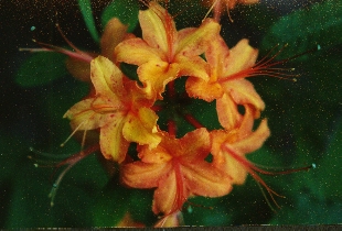
Flame Azalea Near Bartram Trail
(Photo By David Mauldin)
rainmaker@trailquest.net
The Bartram Trail is approximately 111 miles in length. Its southern terminus is located at Russell Bridge on Hwy. 28 in northeast Georgia. The northern terminus is located at Cheoah Bald in western North Carolina.
The trail was named in honor of William "Billy" Bartram, a botanist and naturalist who traveled the area extensively in the period immediately preceding the Revolutionary War.
I'm a little embarrassed that I've lived only a few miles from the trail for the past 16 years, and have barely set foot on it. I finally decided that it was time to hike this beautiful, secluded, seldom used trail that is ranked by Backpacker magazine as one of the 10 most popular hiking trails in America.
Brawny hiked the Bartram Trail previously, and has provided an excellent, printable, ultralight and free on-line guide. To see her guide, use the link above, or click here .
My journal is shown below, and was amended on March 28, 2008 to include the "unoffical" 4.8 mile trail section in South Carolina (see bottom of page):

Russell Bridge - Courthouse Gap (22.5 miles)
April 18 - Brawny and I met Dale America and Mainframe in Clayton, GA at 11:30 a.m. She had met and hiked with both of them during her AT hike in 2002. We'd been planning to get together and hike for quite a while, and I was glad to finally get to meet them. The weather was perfect; a warm and sunny spring day in the north Georgia mountains.
We shuttled to our take-out point and parked just off a gravel road that is near Courthouse Gap. After dropping off Mainframe's and Brawny's vehicles, we all piled into Dale America's car for the 25 mile drive to Russell Bridge on the Chattooga River, which is the southern terminus of the Bartram Trail.
We began hiking about 1:30 p.m., the beautiful "Deliverance" river directly below us. We soon crossed the West Fork of the Chattooga on the first of many well designed bridges that have recently been built on the Bartram Trail. New spring growth was budding out in all directions. It was very pleasant hiking, mostly flat and level and parallel to the river, with four AT thru-hikers enjoying each other's company and conversation.
We soon came upon a long abandoned homesite. There was an ancient hay-baler sitting in some woods. The trees near the machine were 50 - 60 years old, but the flat terrain indicated that the area had once been a field. About 100 ft. down the trail were the remains of a house. Only the chimney and hearth remained. I thought about the family that had once lived here; real people just like us with hopes, passions, dreams and fears. The age of the trees around the hay-baler (and the fact that the homesite was now part of the Chattahoochee National Forest) indicated that the Great Depression had probably caused the family to give up and move away. They'd most likely sold their land for $1 per acre to the Federal government, like almost everyone else in the area had done. They'd probably died long ago, buried in some forgotten cemetery nearby, the only monuments to their existence being a rusting hay-baler and a crumbling chimney.
After we'd hiked several more miles, the sudden increase of trash along the riverbank indicated that we were approaching a road. We suddenly heard a mighty splashing in the water and a straining engine, and looked out into the river to see a Jeep crossing from one side of the river to the other on the old Earl's Ford Road. Soon, another vehicle approached and entered the water, this one with two hopeful but unsure dogs perched on the hood. We stopped and watched. When the vehicle reached the opposite side of the river, both dogs were still high and dry on the hood, but looking a bit relieved that the adventure was at an end.
After encountering some car campers near the ford that kind of set my radar off, we decided to get well past the area before we camped for the night. We hiked another mile and found a beautiful and level campsite on a tributary. We'd hiked about 6.5 miles. It was a very pleasant evening, with everyone listening to and telling trail stories and discussing gear. Later, Brawny and I went to our tent, and I went to sleep listening to owls calling, and the sound of water rushing over rocks in the river.
April 19 - We were up just after daylight. Brawny and I had hot coffee and oatmeal while Dale and Mainframe were packing up, but we all seemed to be ready to hike at about the same time.
Spring growth seemed to be exploding in all directions. The hardwood trees were budding out, and dogwood trees and pink azalea were blooming by the river and in the woods. Everywhere I looked I could see wildflowers; iris, bluets, violets, astor, buttercups and several other species that I couldn't identify. The beautiful Chattooga kept flowing over its massive rocks into emerald pools. Why had it taken 16 years for me to hike this trail? Why did Brawny and I feel this compulsion to drive across the country every summer to hike out west, when we had such beautiful areas in our own backyard? Since I had no answers, I decided to keep the questions to myself and just keep hiking.
As we neared the intersection of the Bartram Trail with the Chattooga River Trail, we stocked up on water. The Chattooga River Trail stayed near the river, and we turned away from the water on the Bartram Trail and began the 10 mile ridge walk to Warwoman Dell. There was no more flat walking by the cool river. We were going up, and so was the temperature. It soon got uncomfortably warm, but the views of Yonah Mountain, Whiteside Mountain and Rabun Bald made up for the discomfort.
We finally began our descent into Warwoman Dell, which is a picnic area. It has several picnic pavilions, a chemical-flush privy and water faucets. However, the water hadn't been turned on, so we got water out of a nearby creek. After our break, we continued our hike, crossing Warwoman Road and hiking past Becky Branch Falls. We lingered at the falls for a while, enjoying the natural air-conditioning before making the last ascent of the day. About a half-hour later, we reached Martin Creek. We soon found a large, level campsite, though we had to rock-hop across the creek to get to the camping area.
Many folks have asked me about the history of the name "Warwoman". When I moved to this area in 1988, I was also curious and asked several of the locals. I got 2 versions. Each person was absolutely positive that their version is the correct one:
1 - Warwoman Dell previously was a meeting place for the Cherokee Indians. When they'd get together, they'd discuss mutual issues. There was a position of authority among the Cherokees that was held by a woman, kind of a "Secretary of State". Among the responsibilities that came with this job was making a decision concerning whether the Cherokees should go to war in any particular situation. This matriach was called the warwoman.
2 - During the Revolutionary War, there was a contingent of British soldiers stationed in Tiger, GA (about 15 miles south of Clayton). They had stripes on their pants, called "tiger stripes" and this is how Tiger got its name. Anyway, 3 British soldiers once staged a home invasion near Clayton of a house occupied by a woman and her son. After consuming a large meal (and possibly some alcohol), the soldiers went to sleep. When they were all snoring, the woman directed her son to remove their rifles. One soldier was blocking the door, so the mother had her son go through the small door on the wood shed that was attached to the house, taking one rifle each trip. When the rifles were safely removed, she told her son to go for help. Meanwhile, she pulled a pistol and awakened the soldiers. When several of the local men arrived, they asked her what she wanted done with the soldiers. She directed the men to hang the soldiers one at a time. This was done, and she was forever known as "The Warwoman".
We had another very pleasant evening in camp, all of us laughing at Dale's "flaming rat" story. Later, I went to sleep listening once again to the sound of water flowing over rocks, and pondering such important issues as who was the real warwoman, what happened to the family with the hay-baler and who was the "Becky" in Becky Branch Falls. I figured her husband or lover named the creek and falls after her. If it had been her father or mother doing the naming, they probably would have called it Rebecca Branch Falls.
April 20 - After packing up and having another hot breakfast, we hiked along Martin Creek for a while, with its many little cascades, waterfalls and pools. We soon came to Martin Creek Falls, which is nearly sheer and drops about 65 feet in two stages. There is a very nice boardwalk and observation deck at the foot of the falls, and we lingered a while.
We then made a sharp ascent and soon reached Courthouse Gap. We took a side trail .6 mile to the road, then turned right on the road and walked about 700 ft. to the cars. Mainframe left for home from the parking area and Brawny and I took Dale back to his car at Russell Bridge. It had been a great hike, and we made plans to take another camping trip along the Chattooga River, next time in canoes.
Courthouse Gap - Hale Ridge Road (14 miles)
April 28 - Brawny suggested that we hike this section from north to south. After looking at the profile, I agreed. On another beautiful spring morning, we shuttled to Courthouse Gap and left one car. We then drove to Hale Ridge Road, and found the point where the Bartram Trail crosses. For all practical purposes for Bartram Trail hikers, Hale Ridge Rd. is the state line between Georgia and North Carolina. However, since the actual border is about 150 yards away, I walked north to the yellow Bartram Trail blaze that said "GA/NC" and tagged the tree. When we got to Courthouse Gap the next day, I wanted to be sure that the Georgia portion of the trail was finished.
There is no actual parking area in this vicinity, so we parked Brawny's car at a wide spot in the road and hiked about .1 mile south to the point where the trail left the road and headed back into the woods. For the first few miles, there were many creeks, springs and small waterfalls. Lots of wildflowers were still blooming, including trillium and mayapple. The dogwoods were still putting on a show, and so were the iris (which is called "blue flag" locally).
Soon we left the relatively level ground and plentiful water behind and began the long ascent of Rabun Bald, which is the 2nd highest mountain in Georgia. The ascent really wasn't bad, the trail is routed mainly on what appears to be the old access road for the firetower that was once at the summit. The firetower has been converted (and the summit closed to vehicles) to an observation deck that provides a stunning, unobstructed, 360-degree view of the surrounding Blue Ridge Mountains.
We had our lunch at the top of Rabun Bald, sitting in the sun at the base of the observation deck. We can see Rabun Bald from home and I've often wondered how far away it is, so I brought my new Garmin 3.8 ounce GPS unit. After allowing this little high-tech device to establish contact with several GPS satellites, it told me our exact latitude and longtitude, accurate to within 6 feet. I recorded this data as a waypoint, then checked the distance from our lunch spot to home, which I'd recorded as a waypoint previously. We were exactly 8.17 miles from home. The GPS unit also gave me a compass bearing to follow, just in case we wanted to walk home from Rabun Bald.
After lunch, we began out descent. Our surroundings looked like a wild and unexplored area, even though we were less than 10 miles from home. About an hour after we'd left the bald, some movement about 100 yds. away caught my eye. Straining to see, I could barely make out the image of a wild turkey moving away from us.
All water sources had disappeared. We planned to stop at a small campsite near a creek that was about 3 miles from our lunch spot. However, the site was too small, so we kept hiking. An hour later, we still hadn't found a campsite and we both wished we'd explored the small side trail near the site we'd passed up previously. Thirty minutes after that, we hiked through Wilson Gap, passing a trashed out car camping area. It was then after 6:00 and we were getting desperate for a place to camp. About 6:30, we came to a small creek and waterfall, and there was a small camping area just off the trail.
Brawny had our tent up in a couple of minutes, and we both got water for the evening meal. A few minutes later and with darkness fast approaching, we were once again at "home" for the night, returning to familiar campsite routines. We got in our tent just before dark. I went to sleep listening to the sounds of the nearby water, and the hooting owls near our campsite.
April 29 - We were up soon after daylight. Our tent site had a slight slope to it, and I'd been "slip-sliding away" to Brawny's side all night. Usually, I'd slide partially off my sleeping pad to my right, and my pillow would then gain escape velocity to my left. This scenario was repeated many times during the night, mainly when I'd turn over on my right side.
With only about 5 miles left to hike to our car near Courthouse Gap, we took our time in camp. I had several cups of coffee while marveling at the tent Brawny had recently made. It is a prototype of a model that we may begin marketing at our business at some point in the future. It weighs only 1 pound 15 ounces and we plan to take it on our section-hike this summer of the Continental Divide Trail, from the Canadian border in Glacier National Park to the vicinity of Helena, Montana. It sleeps 2 comfortably, we can sit up in it and it has everything one expects to find in a tent, including floor, mesh doors and storm doors.
About a half hour after we began hiking, I saw Brawny stop suddenly and give me a look that said she had seen something unusual. Using only a facial expression, I asked her what she'd seen. She mouthed "turkey hunter". This little conversation had taken place without one word being spoken, possible only with 2 people who are tuned-in to each other and who know each other very well. The hunter had silently slipped into the woods, and we weren't sure he'd seen us. I began whistling to let him know that we were around. A few minutes later we saw him again, this time on the trail ahead of us. Just before we passed him, he stopped and put down his shotgun (a fine Browning 12-gauge over-and-under with a 26-inch barrel). This was a gesture I appreciated, and we stopped and talked with him a minute. Hikers are sometimes badly frightened by turkey hunters because of the camo clothing they wear and the rather large shotguns that they carry. However, most turkey hunters are really nice folks, and they mean us no harm at all.
The spring woods were beautiful, and I had mixed emotions as we neared Courthouse Gap. I was anxious to return to the comforts of home, but not really wanting the trip to end. However, there is a consolation. We were only a few miles from home, and we'll probably return to the Bartram Trail next week. We reached the car about 1:00 p.m., then drove to Hale Ridge Road and retrieved Brawny's car before coming home.
Hale Ridge Road - Buckeye Creek (19.0 miles)
May 5 - Brawny and I shuttled to Buckeye Creek parking area and left one car, then drove the other car back to Hale Ridge Road, where we began our hike of this beautiful section.
Rain appeared imminent as we hiked across the state line into North Carolina. I knew that we'd soon be hiking at higher elevations than we had in Georgia. The wildflowers were about done for the year at the lower elevations, but I hoped that we'd still see some wildflowers, along with impressive views, in North Carolina. We got far more than I'd hoped for. This is a very impressive section of trail, and it is North Carolina hiking at its very best.
We walked past many small creeks and cascading waterfalls on new-looking wooden bridges before beginning our ascent of Scaly Mountain. After we crossed busy Hwy. 106 (we saw John, our UPS delivery man driving by; we waived, but he didn't see us), we began climbing steeply. We began to see day-hikers, and I decided that most of them were part of a group, probably from the Nantahala Hiking Club. The views from the summit of Scaly are impressive. We could see back to Rabun Bald and beyond. The trail started to have a "wild" feel to it when we began our descent. All the day-hikers were safely back in their cars for the ride back to the comforts of the resort community of Highlands, NC. We had the Bartram Trail all to ourselves once more.
We began switchbacking between two cascading creeks (one on our left, the other on our right) as we descended toward our Tessentee Creek Campsite. The two creeks we'd been following finally merged just below the bridge we crossed to get to the camping area. The place was beautiful. Brawny had our tent up in a couple of minutes, and we got water for the evening meal. As I was sipping coffee, I heard a frantic clucking and fluttering of wings. I looked to my left to see a rapidly departing hen turkey flying into some nearby trees about 25 ft. away.
We got into our tent a few minutes before dark, just as the full moon was rising. I heard a Barred owl hoot, and decided to try to call him closer. So, I answered his call with my best owl imitation. To my surprise, two owls answered. I smiled to myself since I knew what was probably about to happen. I called (hooted like an owl) several more times. In all, 3 owls answered and moved very close to our tent. I have observed and listened to owls for many years, and I think I've learned a bit about their habits and behavior. Apparently, they sleep all day, then hunt (and socialize) all night. Sometimes when an owl is sitting in a tree and hunting for dinner, I think he gets a bit lonely. Taking a break, he hoots, which in owl language is "I'm here, where are you? Want to get together and hoot for a while?". If he can get one or more owls to answer, they congregrate and start a good natured competition of hooting, each one trying to outdo the others. I think they award points for longest hoot, loudest hoot and most creative hoot. Anyway, I knew we were about to have a hooting contest just outside our tent. I called once or twice more, and they really got it going. The noise they generated in the still of the night was both thrilling and enjoyable. However, since it was Brawny's first group hoot (I've been involved in several), I knew that it was probably a bit unnerving. The owls were very close and very loud. The hooting lasted about 5 minutes. Socializing done, they flew away to their separate areas to resume hunting and terrorizing the local rodent population. Wild things happen in wild places. Just before dozing off, I tried my Whipporwill call once. I got no response. I think Brawny was relieved. I believe she'd about had her fill of large, noisy birds for one night.
May 6 - The remainder of the night was quiet, and we were up at daylight. The skies had cleared, and the day was sunny and pleasant. We made a very steep and rough ascent that reminded me of the northern portion of Vermont's Long Trail. However, the wildflowers were spectacular. Everywhere I looked, something was blooming. My favorite wildflower is trillium, and it was in profusion. There was trillium of every type, often blooming alongside violets and bluets. We reached the top of one knoll and there was more blooming trillium than I'd ever seen in one place. There were literally hundreds (thousands?) of plants covering an acre or more. Carol also spotted some rare yellow ladies slipper in bloom.
We took our lunch break at the top of a ridge, near an abandoned 1950's era school bus. Brawny had seen this old bus on her previous hike of the Bartram Trail, and I'd been looking forward to seeing it and trying to figure out the story behind it. No trace could be seen of the road that had once been used to get the bus to the top of this mountain. A tin roof (now collapsed) had been placed over the bus. There was no water in the vicinity. I had almost convinced myself that a couple of men used the bus as a week-end retreat, perhaps as a hunt cabin. However, then I noticed the neatly finished underpinning, apparently added for aesthetic purposes. It was not something a couple of hunters would have had any interest in. Had someone actually lived here? A small family perhaps? It is another piece of Bartram Trail lore that will probably remain a mystery.
We had many spectacular views on this section of trail before finally beginning our descent to Buckeye Creek. However, after hiking 11 miles in rough terrain, we were both ready to reach the car. We finished our hike about 4:30. After retrieving Brawny's car at Hale Ridge Road, we had an early dinner in Highlands, NC before coming home.
Buckeye Creek - Wallace Branch (14.0 miles)
May 12 - I day-hiked this least attractive and least representative section of the Bartram Trail. The trail in this section is entirely on secondary roads, and all except .6 mile is on pavement. However, as roadwalks go, this is a good one. Except for the couple of miles that are near the outskirts of Franklin, NC, the route goes through very attractive rolling hills, traversing farm land and pastures with brief patches of woods. Usually, there are good views of the distant Nantahala and Fishawk Mountains.
I parked my car at the northern end of the section (Wallace Branch parking area), and began hiking south toward Buckeye Creek at 9:10 a.m. Soon, I crossed under Hwy. 64, hiked past Westgate Shopping Plaza, then crossed very busy 5-lane Hwy. 441. After crossing the highway, I was back in pleasant, rural countryside. After hiking about 5 miles, I stopped and had a break. A couple of dogs barked at me the entire time, but didn't try to approach closely.
I reached the approximate half-way point of this section (Prentiss Bridge) at 11:49. There is public access here for the Little Tennessee River, and an emergency campsite (probably the only one in the entire 14 mile section) could be made in a grassy area adjacent to the parking lot.
Not far from the bridge, I saw some of my favorite Fire Pink wildflowers blooming. I really like the flower, but don't like the name. I think Starfire would have been much better. I was also very surprised to see a large stand of Coral Lichen growing right on the side of the road, up on a bank about 15 ft. from the pavement. Coral Lichen takes forever to grow, and can easily be crushed by tires or feet or destroyed completely by mowers. Somehow, this group of plants was surviving nicely despite its proximity to the road and civilization.
I didn't have much to do while hiking except look at my surroundings and watch for dogs. At this point, the dogs hadn't been much of a problem; just a few little woofers that didn't seem to want any trouble. I tried to get a feel for what is going on with the homes and land. Moderate development is occurring, with a number of family farms apparently being acquired by developers. Land that was pasture a few years ago is now touted as "cleared homesites with fantastic views". However, it also appears that some family farms are still intact.
Eventually, the route turned off Hickory Knoll Rd. onto Tessentee Rd. The dog situation changed for the worse. There were two places where there were extremely vicious dogs in the yard. Thankfully, they were all chained. To get as far from the dogs as possible, I crossed to the other side of the road where I was welcomed by a small, fenced herd of friendly and inquisitive goats. A little while later, a beautiful Palomino horse ran up to the fence near the road and walked with me as far as she could.
I noticed several old homesites and barns that had been abandoned. The land (and buildings) were being reclaimed by nature. Vines and other plants were covering the buildings, and trees were growing in what had once been fields and pastures. I saw one old farmhouse that was only about 20 ft. from the road, but it was almost invisible because of the large evergreens that were growing around it. I'm intrigued by such places, and I always wonder about the folks who used to live in them. Who were they? When did they live? Why did they leave? Where did they go?
When I stopped to drink the last of my water, I saw an old roadbed snaking up to the top of a wooded knoll. On the knoll was a small, abandoned cemetery that had been completely reclaimed by woods. I made a mental note of its location, and plan to go back and investigate soon (maybe this is where the previous residents of the old farmhouse ended up). I also saw a grandfather oak that had to be at least 200 years old. It appeared to be in very good health, with many thick branches extending outward 40 - 50 ft. from the trunk of the tree.
The dog situation kept getting worse. About 2:00, I was hot and tired and I'd had about enough. I started barking back. I'm not sure whether it was the owners or the dogs who were the most surprised, but I got some funny looks from both species.
Finally, I turned onto Buckeye Branch Rd. for the final .6 mile. I reached the Buckeye Creek parking area at 2:28, figuring that doing 14 miles in a little over 5 hours wasn't too bad at this stage in my life. Brawny arrived in her car about 3:00, and we drove to Franklin, NC to retrieve my car and have an early dinner.
Wallace Branch - Sawmill Gap (14.7 miles)
May 19 - This is a very scenic, remote, rough and steep section. We hiked it southbound. After leaving one car at the Wallace Branch parking area, we drove to Sawmill Gap and began hiking toward Wayah Bald. After a mile or so, we came to the spot where the Bartram Trail and Appalachian Trail converge. For several miles, the two trails share the same treadway. It was a bit odd seeing trees that had both yellow and white blazes.
We began to see more backpackers, and by the time we got to Wayah Bald, we were seeing day-hikers as well. The views from the overlook at the bald were impressive. We began descending and soon reached our campsite, which was located at the area where the Bartram and Appalachian Trails go their separate ways. Rain was threatening, and we put up both our tent and the tarp. The tarp was mainly for my benefit; so that I could sit outside with my backrest (external frame pack leaned against a tree) and have some rain protection. After we got water from the creek located about .1 mile away, the rain started. It was a spring thundershower, and it lasted about a half hour. Later, it cleared.
We were tired, and were in our tent before the sun went down. It was a quiet night, however, we were awakened about 3:00 a.m. by an owl that was just outside our tent. His hooting wasn't real creative, but I'll give him credit for volume and persistence.
May 20 - We were on the trail before 8:00, however, we stopped at the nearby creek to get water. We knew that the day was going to be long and probably hot, and that this was the last reliable water before we arrived at Wallace Branch. I mistakenly thought that this section would be mostly downhill (since we were descending from Wayah Bald), however, it wasn't. We kept gaining and losing the same 500 ft. of elevation. I noticed that the trail here had probably been built over 30 years ago, since it tended to go straight up one side of a mountain and down the other. If the trail had been recently built, switcbacks or sidehill construction would have been used. However, the views from the tops of the ridges were very nice.
We began to see old growth trees, mostly white oaks and chestnut oaks. Some were probably about 250 years old. I took a close look at the forest, and decided that this inaccessible and steep area had probably never been logged. There were also many old growth trees that had died and were lying on the forest floor.
We began to get slowed a bit by blowdowns and the poison ivy that was on both sides of the trail. We also saw a small snake, so I was also on "snake alert" the remainder of the day. We had problems finding a place for our lunch break and hiked several miles more than we wanted before we found a clear spot underneath some hemlock trees. After lunch we saw a couple of volunteer trail maintainers who were clearing weeds and we thanked them for their work and sacrifice. Cutting poison ivy while standing knee-deep in it and contending with hot, humid weather (and snakes, underground hornet nests and biting insects) so that folks you don't even know can have a pleasant hiking experience is something that not many of us will do.
We finally reached our car at Wallace Branch parking area. Since we had both been wearing shorts while walking through the poison ivy, we waded into the creek and thoroughly washed our legs. We then drove back to Sawmill Gap and retrieved the other car. Before going home, we stopped in Clayton, GA and did some serious damage to the buffet at the Chinese restaurant on Hwy.441.
Sawmill Gap - Cheoah Bald (25.7 miles)
June 21 - Brawny and I began hiking at Sawmill Gap under threatening skies after shuttling a vehicle to Winding Stair Gap on Hwy. 19 (not to be confused with the other Winding Stair Gap where the Appalachian Trail crosses Hwy. 64 west of Franklin, NC).
It was one of those days when you knew it was going to rain. The questions were just when would it start, how long would it last and how much rain would fall. We got on the trail about 11:30, and the first thunderstorm hit about 1:30. Actually, it was very hot and the rain felt pretty good. However, I had sprayed DEET on the underside of the bill of my cap and on my mosquito headnet, and the rain water washed the DEET into my eyes. It burned badly, and I had to stop every minute or so and wipe my eyes.
The trail was badly overgrown, and there were many blowdowns. The descent to Nantahala Lake was steep, and the rain showed no signs of stopping. The going was pretty rough, and the slippery mud was treacherous. This was one of the least maintained sections of the Bartram Trail that I'd seen. We were very glad to reach the road at the edge of the lake. The worst of the rain was over, but it was still coming down. We followed the road about .7 mile before getting back into the woods, walking right past a restaurant and a Phillips 66 gas station / camp store. Since we'd started late, and needed to hike a total of about 10 miles to reach our campsite, we didn't stop at either place.
We reached Appletree Group Campsite late in the afternoon. It was way too developed and crowded for our tastes (and being just the two of us, we figured we didn't qualify as a "group", anyway). We continued hiking about a mile, and finally found a flat place to camp by the Nantahala River. We didn't worry much about bears, figuring that just about every bear within 10 miles would be heading for Appletree Campground for the evening festivities (food scrounging, scaring the heck out of Boy Scouts, and generally running amok).
We recently bought Garcia bear canisters (for securing food), mainly for use in Grizzly country this summer in Montana and next summer in Yellowstone on our hike of the Continental Divide Trail. This was our first test of packing the canisters. For anyone who has not used a bear canister, putting one of them into your pack is kind of like bringing a 500 pound gorilla into a small room. The gorilla takes over the middle of the room, and the furniture and furnishings are delegated to the walls and corners. Although we didn't expect any problems with bears, we dutifully packed all our food and placed the canisters about 100 yards downwind of our tent. It was a quiet, but very dark night. At one point, I awoke and couldn't see a thing. Fearing that the DEET had caused some type of eye problems, I turned on the light on my watch. Satisfied that I could still see, I managed to go back to sleep.
June 22 - We were on the trail about 8:00. The hiking was pleasant, the mostly flat trail following the Nantahala River for a ways. Soon, though, we were going back up to the crest that separated us from Winding Stair Gap and Hwy. 19. It felt like it was going to be a long way up, and then a long way down. The rain dutifully started about 1:30 (same as the day before), and continued several hours. We began seeing 3 - 4 groups of young men who were out on overnight trips with their leaders. We stopped for lunch at a trail junction. Even though the Bartram Trail was clearly marked, two of the groups took a wrong turn and would have headed out on the London Bald Trail if Brawny hadn't turned them around. Embarrassed, they continued on their way. None of them appeared to be too happy about hiking in the rain.
Even though it was a hot summer day, we knew the potential existed for wind and rain to create hypothermic conditions, and we'd both packed silnylon rainwear. Sure enough, both of us got chilled and we put on our rain jackets. We passed one group of young men who were huddled under a tree. Some of them appeared to be dressed in cotton shirts and shorts, and they looked cold, wet and miserable.
We stopped at a shack near a water tower to put on our rain gear. The shack had an overhang, and we took momentary refuge from the rain while we opened our packs. I noticed a new-looking Nalgene water bottle that someone apparently had abandoned. It was one of the new brightly colored models. Even though the owner had paid about $11 for it, I suppose that he or she figured that no matter how pretty it was, it weighed nearly 7 ounces and was too heavy for just hauling around a quart of water. An empty Gatorade, soda or purified water bottle does just as well, and they are free and weigh just over an ounce. One bottle that I'm using (that originally contained some kind of sports drink) has been with me since 1999. I used it on the entire length of the Pacific Crest Trail, Long Trail and Colorado Trail, and it is going to the Continental Divide Trail this year, too. It has been used for over 3,000 miles of hiking, and it has never leaked. I'm not sure what I'll do with the colorful Nalgene bottle, but I packed it out. On my AT hike in 1992, I carried four Nalgene water bottles that weighed a total of about 27 ounces. I now carry 4 bottles that weigh less than 6 ounces (total).
We finally began our descent to the Hwy. 19 / Nantahala River / Winding Stair Gap / Nantahala Outdoor Center area. We walked past my car at Winding Stair Gap, and I dropped off the Nalgene bottle. We planned to hike about a half mile past the highway and camp at a site mentioned in the guidebook. However, we didn't care for the site, and decided to continue hiking 1.5 miles to another site that was near Ledbetter Creek. The rain had finally stopped, but we had to ford the rain-swollen creek several times while making a 1,000' ascent. No matter where we hike, or what direction we hike in, the trail gods usually manage to sneak in a substantial ascent right at the end of the day. We've gotten used to it; it is just part of the hiking tradition. No one knows how the trail builders pull it off, though.
We finally reached our campsite about 6:00. We'd done 13 miles in hot and humid conditions with a hard ascent at the end, and we were tired almost to the point of exhaustion. We'd escaped the crowds, and had managed to get ourselves into a very wild looking place.
June 23 - About 1:30 a.m., I was awakened by what appeared to be a white Photon light being shined into our tent. The bright white light went off, moved a few feet and then came back on. Then it started floating. I then realized that the "Photon light" was actually a firefly. Later, I was sleeping soundly when I heard Brawny yell, "Hey, you! Get out of here!" I awoke with a start, saw that it was barely daylight, and that Brawny was not in the tent. It took me a second or two to realize that her comments were directed at a wild animal, and I scrambled out of the tent. However, my assistance had not been needed. Brawny had been on her way to pick up our bear canisters when she'd seen a large Black bear 40 - 50 ft. from our tent. She'd sent him packing. It was quite a jump-start for the new day.
Brawny had previously completed the Bartram Trail and had offered to stay in camp and watch our gear so that I could make the steep ascent to Cheoah Bald without my pack. I didn't figure that the mere presence of a 350 pound bear would change her mind, and it didn't. After breakfast, I was on the trail and headed up to Cheoah Bald, which is the northern terminus of the Bartram Trail. I had to cross Ledbetter Creek several more times. It really didn't matter, all my clothes were wet from the previous day's rain, anyway. For about 2 of the remaining 3 miles, I was hiking in a narrow gorge along the creek. There were many cascades and waterfalls. In some places, the gorge is only about 30 feet wide, and there are nearly vertical walls on both sides that appear to be several hundred feet high. It is a beautiful and wild area; the wildest area on the Bartram Trail, in my opinion.
Several hours later, I reached the intersection of the Appalachian Trail and Bartram Trail. I turned right and hiked the final half mile to Cheoah Bald. Fog covered the bald and there were no views of the distant mountains, however, I did see the most beautiful display of wild azalea that I've ever encountered. A multitude of the light orange and blaze orange varieties was in bloom. The brightly colored blooms stood out like beacons in the gray fog. About 10:30, I tagged the "Cheoah Bald" sign. I had a snack and then began the long, slow descent back to our campsite at Ledbetter Creek.
Although not mentioned as part of the "official" route by the Bartram Trail Society, Carol and I noticed that on certain South Carolina and US Forest Service trail maps, there is a small section of trail in South Carolina that is noted as being a part of the Bartram Trail. Also, we have had several people ask us if we had hiked the "South Carolina portion" of the Bartram Trail. Therefore, on March 28, 2008, we decided to day-hike this trail section.
Russell Bridge - Foothills Trail Intersection (4.8 miles)
To access this section, proceed about .2 miles on Hwy. 28 south of Russell Bridge into South Carolina. There is a parking area on the east side of the highway, and the trail starts just past the locked gate.
On some older maps, the length of this trail section is listed as 3.6 miles in length. However, the newer maps show it as 4.8 miles. Carol and I agreed that 4.8 miles is the accurate mileage. The main purpose of this trail is that it connects the Foothills Trail to the Bartram Trail.
We had a warm, overcast day which was very pleasant for hiking. We began our hike on sidehill trail that climbed to about 200 feet above (and on the east side of) the Chattooga River. We crossed several small creeks within the first mile or so, and saw some early-season wildflowers, mainly violets, bloodwort and some mayapple. There were some minor ups and downs, but nothing major. After about 2 miles we began a very gradual descent, and soon we were hiking on an old roadbed right beside the river. We passed several beautiful campsites, and after about a mile, the trail left the river.
We later encountered Licklog Creek, and I could hear a large waterfall nearby. A few minutes later, we came to a beautiful, 2-tiered waterfall. The lower tier is a rocky cascade about 40 feet in length, and the upper tier has a nearly sheer 40 ft. drop. We then crossed Licklog Creek on a small bridge, where there are several camping areas, along with a cascading waterfall that has a large pool. We then followed the trail an additional .2 miles to the intersection of the Bartram and Foothills trails. The intersection is well-marked, with several signs. Once again, Carol and I congratulated each other on completing the Bartram Trail. We just hope there's not another section in Alabama or Tennessee.
--David "Rainmaker" Mauldin
June 24, 2004 (amended March 28, 2008)