Bartram Trail
The Bartram Trail is a footpath that travels through the Chattahoochee National Forest in Georgia and the Nantahala National Forest in North Carolina. The Bartram Trail Conference is a very informational site with maps and history of William Bartram's extensive travels through the southeast.
On the Great Outdoor Recreation Pages, the Georgia Bartram Trail is well discribed, and maps can be seen of this trail. At North Carolina Bartram Trail Society you can buy trail maps, seven in all, for $2.50 each.
I bought the trail guide in 2003. A two volume set of the Bartram Trail Guide is sold at this site. This guide is very detailed for the trails it covers, including the Chattooga River Trail (10.6 miles) and Three Forks Trail (3 miles). There are historical notes, basic maps, a profile map, and trailhead and road access points written in fine detail. In my opinion it is not hiker friendly, being printed on 8 1/2 x 11 inch cardstock, and spiral bound. It is printed in two volumes, and together they cost $12.The Georgia guide is 22 pages. The N. Carolina volume (30 pages) alone weighs 3 ľ ounces, and covers 60 miles of trail. The road walk of 14 miles, which connects the first 19 miles of the NC Bartram Trail to the last (northern) 41 miles, is not included. By comparison, the Colorado Trail guide weighs only 1 7/8 ounces, and covers 468 miles. I cut portions from the Bartram Trail guide to use while I hiked, then taped them back in the book when I got home.
A professional trail crew was hired a couple years ago to repair and upgrade this trail. Some of the trail was rerouted, and not all mileages that were once carved on rocks previously still apply. This data sheet may change at some future date, but at present it is accurate to the best of my knowledge.
My notes and a hiker friendly data sheet follow. Set your font to small, and print. Laminate if necessary, or carry in zip lock bag. Miles are heading north, and in parenthesis heading south. All data points are for solid, easily recognizable places. In Georgia, the trail was well marked with yellow diamond metal blazes nailed to trees. Watch for double blazes, which indicate a difficult intersection or abrupt turns. These are always followed by a marker in the new direction. The North Carolina section had rectangular yellow blazes, at times not as visible as those in Georgia, but definitely enough to see you through.
If you read Rainmaker's Bartram Trail Journal, you will have a very good idea about this trail, what to expect, and how enjoyable it will be.
There is a 4.8 mile trail linking the Foothills Trail to the Georgia/N.Carolina Bartram trail. It is the South Carolina portion of the Bartram Trail, and is not included in the above purchased guide. It begins at the turn off to Licks Log Creek from the Foothills Trail. There is camping there, and a wonderful waterfall. You can access this junction by either parking at Hwy 107 and hiking in 2.4 miles heading west on the Foothills Trail, or from the Nicholson Ford Road parking area, and hiking in .8 miles west on the Foothills Trail. We parked at Russel Bridge (S. Carolina off road site) and hiked past the gate, up onto the trail. Along the way we crossed several water sources, saw many violets just blooming, and enjoyed the views of the Chatooga River. We noted several excellent campsites along the river as well. Taking a brief lunch break at the actual beginning of the Bartram Trail, we then back trailed to make a 9.6 round trip.
Much of the Georgia trail is near, or crosses water, with campsites close to the Chattooga River the first 8.5 miles. Further north, during drought, or summer, some small streams may dry up. An asterisk on the data shows where last sure water is, and the next source in miles is indicated.
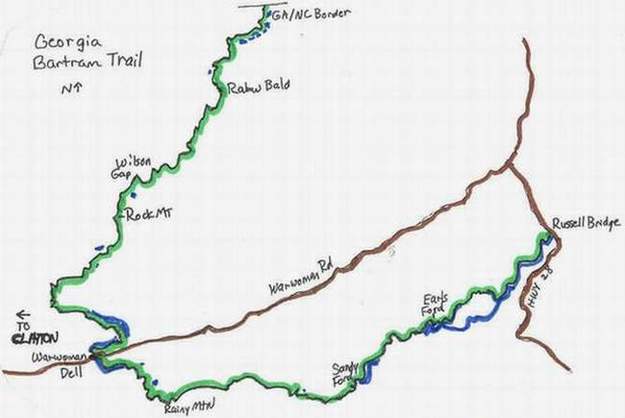
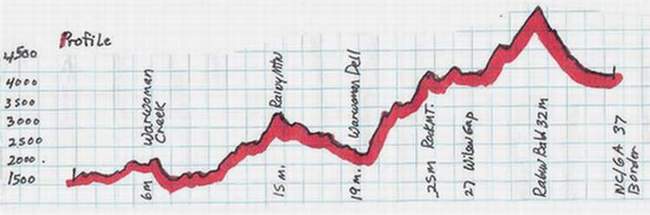
Georgia Bartram Trail - 36.5 miles
Southern Terminus - Russell Bridge, parking lot is on the left side of Hwy 28, just south of the S.Carolina/Georgia state line.
Cross road, get on trail directly across.
.3(36.2) Cross 112 foot metal footbridge
2 (34.5) Pass a rusty baler on left, and ruins of an old homesite on right.
2.5 (34.0 ) Cross Adline Branch on wooden bridge, best water for next 3 miles.
3.2 (33.3) Cross Bynum Branch on wooden bridge. Water was scanty here, but there's a campsite on left hand side of trail.
4.3 (32.2) Cross another wooden bridge over a stream, with campsite.
6.3(30.2) Cross 66 ft. metal bridge, and in .2 cross Earl's Ford Road.There are some established, flat campsites here.
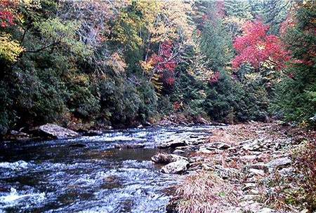
As you walk along the Chatooga river for the next 2 miles, there are some exceptional campsites. These are the last good campsites, with water, until you reach Martin Creek, about 11 miles away.
9.1 (27.4) Dick's Creek Falls. Be sure to pick up water at the stream near Dicks Creek Falls, ****next sure water is near Warwoman Dell (9 miles), but you might cross a couple water sources in 6 miles depending on season.
9.4 (27.1) Intersection with the Chatooga River Trail
9.5(27.0) Cross Sandy Ford Road, carved rock says Bartram Trail.
11.4 (25.1) Cross road with rock carved, Speed Gap.
12.9(23.6) Cross Pool Creek Road, at Bob Gap. There are a couple dry campsites in the next 2 miles.
15.2(21.3) A 90 degree turn, to the right, off old jeep road, well marked, skirts Rainy Mountain to the north. Should be water in this vicinity in small streams, just off trail, which can be heard, if not seen.
17 (19.5) Intersect Goat Trail marked with metal goat-shaped blazes attached to trees.
17.3 (19.2) Green Gap
18.1 (18.4) Cross stream on wooden bridge.
18.8 (17.7)Warwoman Dell. With Picnic tables and Warwoman Road access. This is strictly a picnic area, no overnight camping allowed. The town of Clayton is 3 miles west. For northbounders, this would be a left hand turn; for southbounders, a right turn. Clayton has a Super Walmart, lots of restaurants, and motels.
18.9 (17.6) Cross Warwoman Road
19.8 (16.7) Trail climbs and moves away from Warwoman Road, along small stream, and then approches the bank of Martin Creek. Decent campsites here. There is an unusual trail routing here, where you cross Martin Creek on a small wooden bridge, walk up the other side to view a fantastic waterfall, cross Martin Creek again on a very well done wooden bridge with viewing platform, and return to nearly the same place you crossed previously. Then, following the blazes you head up the hill to continue north.
21.4 (15.1) Cross various streams on rocks
22.5 (14.0) Pass through Courthouse Gap, which is marked with a sign nailed to a tree. The Bartram trail ascends from here. A short (.6 miles) side trail, marked with white splashes of paint, lead down to a parking area, easily accessible with a small car. To access this parking area, take Warwoman road out of Clayton for .8 miles, and you'll see a sign for Pinnacle Camp. Take a left turn off Warwoman Road onto Pinnacle Dr. Follow that road all the way, 1.1 miles, passing the camp, to Courthouse Gap Road. Take a right, and go .2 miles until you see a gravel road, with parking areas beneath power lines. Park there, and walk up that road about a tenth of a mile, over one culvert, until you see the trail heading left, up some rock steps, just before a second culvert. This trail passes water, but no campsites, as it ascends to the Bartram trail.
26.0 (10.5) Windy Gap
26.8 (9.7) Cross small stream in Rhododendron, last campsite with water for next 3 miles
27.3 (9.2) Wilson Gap, crossing a dirt road, with dry campsites. They say this gap is accessible with a four wheel drive in dry weather.
29.5 (7.0) Small stream and tiny campsite trailside. Contine a bit further and on left is a short unmarked sidetrail leading to better campsite beside stream.
30.5 (6.0) Saltrock Gap, elevation 3700 feet. Dry campsite.
32.3 (4.2) Rabun Bald, with observation platform, great views, elevation 4,696 feet.
33.9 (2.6)Bee Gum Gap, house 50 feet on left. Cross the road.
36.4 (.1) Cross many footbridges and streams, arriving Hale Ridge Rd.
36.5 GA/NC border
Trail Notes, for Georgia
January 11th, the GATC, Georgia Appalachian Trail Club, was offering an overnight hike on the northern section of the Bartram Trail. It sounded like fun, and although temperatures were predicted for the low teens, I decided to go. We met in Clayton at the McDonalds, drove down Warwoman Road to leave all but one vehicle, then we brave 5 souls headed to the NC/GA border, on Hale Ridge Road. It was cold, and I wore nearly all my clothes, with my silnylon rain suit on top. My pack weighed just under 12 pounds on our fish scale, which included 24 ounces of water, and two days of food, plentiful for winter. We parked, and headed south before 10 a.m. Ice was still on parts of the trail. The new wooden footbridges were basically clear, though, and crossed streams flowing well. Plenty of water. We reached Rabun Bald for lunch, the highest point on the GA section, at 4,696 feet. A marvelous 360-degree view and windbreak from the viewing tower made this a fairly comfortable stop. After an hour break, we headed down to Wilson Gap, the intended camping spot. The hike was very pleasant, and the winter views wonderful. We camped on a flat area about one-tenth of a mile before the next water. After setting up tents, we went to get the night's water; all of us knowing it would probably freeze. The night seemed long, and the temperature went down to 11 degrees. I had dumped all my water, except 6 ounces in a bottle for last drinks, and filled my pot and cup. Others tried sleeping with theirs, but by morning, it was frozen and useless.
I ate an early breakfast, thawing water on the stove, packed up, shook the frost out of my Tacoma tent, and headed out before the others. Because of the cold we all decided to hike at our own pace, and meet in the Dell, at the cars. The trail was beautiful, and mostly downhill. It was also well marked, and had been rerouted around the campground listed in the guidebooks. Water was plentiful, and an astounding waterfall was just .1 mile before the Dell. Just after noon, I arrived at my car, dumped garbage, and ate a snack. It had been a good overnighter.
** ** ** ** ** ** ** ** **
I parked my car at Russell Bridge, the southern terminus of the Bartram Trail, and started hiking by 7 a.m, alone on the cloudless, cool morning of March 3rd. The path was near the river and the only sound was water and two vehicles on Hwy 28. The trail crossed a metal bridge, then several new wooden footbridges. A sign was posted for no horses, then another, and written beneath it in black magic marker "Please!" A large bird took flight, and a few small birds twittered in the brush. It was amazingly green with all the pine trees, ferns, Rhododendron and moss. The metal diamond shaped, yellow blazes were well spaced. As the well-graded trail headed towards a mountain, I prepared to climb. Having thru-hiked the AT, I expected several Pointless Ups and Downs (PUDS), this being Georgia and all. But, just like the profile showed, it stayed reasonably level, and wound around the mountains. By eleven o'clock, I had passed Sandy Ford Road, heard two fellows with a chainsaw down in a gully, and headed towards Bob Gap. Until there, plenty of water could be found.
The trail took a sharp right about 2 miles past Bob Gap, as it skirted northwest of Rainy Mountain. I had been daydreaming, and blew past the well-marked turn, staying on a jeep road. But, it was soon obvious something had changed, so back trailing, I found the turn off. The trail became more challenging, and the two mountains on the profile were reached.Then, I descended to Warwoman Dell, and waited for Rainmaker. Other than the two men, who didn’t notice me, I had seen no other people on the trail, and heard 3 cars. I checked my watch. 2:30, and 19 miles. A good day hike.
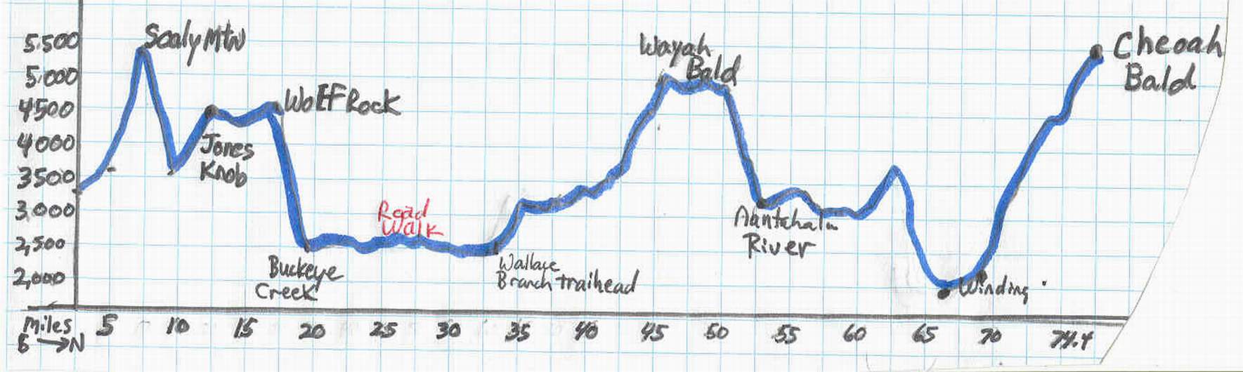
North Carolina Bartram Trail , 74.4 miles
This trail is quite unusual. Its northern terminus is on Cheoah Bald. In the month of October, when Forest Service Road 249, Nolton Ridge Rd. is open, it’s a .9-mile hike to the top. The other eleven months, one must chose from other alternatives. I chose to park at the Winding Stairs Trailhead, and hike the 5.1-miles up to the Bald, then return via the same route. I carried only a daypack, making the 3,000-foot ascent from the Nantahala River to the Bald much easier. This 10.2 mile round trip is strenuous, but there is plenty of water because you cross Ledbetter Creek about 7 times, sometimes on slippery rock. Be sure to wear shoes with good tread. There are good campsites in this section as well.
From Cheoah Bald to the Wallace Branch Trail head there are 41.2 miles of well-marked trail. Then there is a 14.2-mile road walk through the town of Franklin, N.Carolina. This road walk was not included in the trail guide I bought, but I was able to obtain written directions from the authors of the guidebook. The road walk joins the last segment of the N. C. Bartram Trail at Buckeye Creek Trailhead. From there it is 19 miles to the North Carolina/ Georgia Border, just .1 of a mile past Hale Ridge Rd.
If one adds up all these mileages, including the 5.1 to reach the summit to begin the hike, it is 79.5 miles.
Hunters use this trail during the various seasons, so be sure to have bright colors. I found hiking poles to be especially useful on this trail, which is steep in places, and sometimes narrow with uncompromising ridges. Most of the time it's slippery with a lot of leaf coverage, especially when wet, which is often the case.
Mileage data follows. The first number is miles from the GA/N.Carolina border, including the road walk,heading north. The number in parenthethis is from the northern terminus hiking south. These mileages were complied using various data sources, and are approximate.
NC/GA Border, at Hale Ridge Rd, to HWY 106 (3.6 miles)
You can drive to Hale Ridge Trailhead by taking Hwy 106 west for 7.3 miles from Highlands, N.C until you come to the village of Scaly Mtn, NC. Then, turn left onto Hale Ridge Rd, and follow that 2 miles until it bears left, while Bald Mtn Rd curves right. Continue on Hale Ridge Road. It becomes gravel, and in three-tenths of a mile you'll see the Bartram Trail sign on the right hand side. There's parking for about two vehicles.
I did this short and beautiful section as a day hike, only 7.2 mile round trip. This part of the BT was marked with yellow, rectangular blazes, unlike the diamond ones found in Georgia. I parked at Hwy 106, headed south to Hale Ridge Rd, then returned. It took 3 hours. I did not see a soul on the trail. The fall color was near peak, and marvelous.The data is given heading north into N.Carolina.
.0 (74.4)From the crossing of Hale Ridge road, follow the sign, going to the left about .1 mile. There is a large sign directing you to the Bartram Trail.You will be crossing numerous plank bridges spanning creeks, waterfalls, and drainages.
.9 mile ( 73.5) Small campsite to right.
1.5 (72.9) Cross several intermittent streams on slippery rocks in the next half mile.
2.0 (71.2) Cross stream on plank bridge, with rock steps heading down. Campsite up above trail on right.
2.6 (71.8) Intersect Hurrah Ridge Trail on the right. Watch for yellow blazes. The Hurrah Ridge Trail is blazed blue.
3.0 (71.4) Cross two plank bridges over fast flowing streams, then arrive at the West Fork Trail which bisects the Bartram Trail here. Great campsite to left of intersection. Bartram Trail is straight ahead.
3.6 (71.8) Reach Osage Mtn. Overlook on Hwy 106. This is 5.8 miles west of Highlands, N. Carolina. There is parking here. Cross Highway to resume trail.
HWY 106 to Tessentee Creek Campsite (4.4 miles)
After crossing the very busy, and potentially dangerous highway, begin climbing steeply. There is a 1100 foot ascent within just 1.5 miles.
Once on top Scaly Mtn., there are fabulous vistas of the Appalachian Mountains.
3.9 (71.5) Cross stream on rocks and roots. This is the last abundant, sure water until you reach Tessentee Creek, 4 miles north.There were two other intermittent sources flowing this autumn, but in a dry season, not to be relied upon.
4.4 (70.0) Big white house near trail. Take care, especially southbound, because a good trail splits off from the Bartram trail and leads directly to that house. Watch for the blazes.
5.0 (69.4) Trail intersection, and sign for Scaly Mtn, with a blue blaze trail for Hickory Knut Gap Road, elevation 4600 feet.
5.5 (68.9) Scaly Mtn. Summit 4804 feet.
7.2 (67.2)Begin descending, at times steeply, passing a small dry campsite on right. Several well made switchbacks take you from one ridge with a stream cascading out of site, to another stream on the opposite end of the switchback. You can hear the water, but cannot see it until you near the confluence at the bridge. A delightful surprise. As you hike down this mountain, two streams flow in valleys separated by the descending mountain, and all of it meets at a marvelous campsite.
8.0 (66.4) Arrive at Tessentee Creek, with bridge and good, abundant water, large campsites. Note: *** No reliable on trail water for 9.7 miles.**
Tessentee Creek to Fishhawk Mtn. (5.6 miles)
Trail merges with road, and at
8.2 (66.2) Sharp turn to right, up old log steps, while road continues straight ahead. Trail follows switchbacks, up,down and around marvelous views
9.7 (64.7) Switchback up to Hickory Gap. Cross old road, sharp turn heading up another set of old log steps. Wooden sign reads Jones Gap, and Osage Overlook.
10.8 (63.6) Jones Gap, gravel parking area, with information sign.( This parking area accessable from HWY 106, via Turtle Pond road, then turn left onto Dendy Orchard Rd, then, after 1.7 miles, turn left onto gravel road, just after house on right, at the top of a hill). Cross parking area, and head up trail, north of the sign.
11.1 (63.3) Sharp turn to right, blue blaze trail goes left.
12.1 (62.3) Wooden sign for Whiterock Gap, elevation 4150 feet. Steven Creek is 900 feet down steep side trail. Campsite.
12.5 (61.9) Short trail (50 feet) to right, intermittent water source (flowing wonderfully May 2004).
12.6 (61.8) Trail to left for Whiterock Mtn., Bartram trail continues to the right.
Great views both east and west, as you walk the ridges.
13.4 (61.0) Gap with small possible campsite, between little Fishhawk and Fishhawk Mtn.
13.6 (60.8) Blue blaze trail up mountain.
Fishhawk Mtn. to Buckeye Creek Trailhead (5.4 miles)
13.8 (60.6) Water seepage across trail, too scanty to rely on, elevation 4,500 ft.
14.4 (60.0) Decend switchbacks, cross small gap , and continue on narrow ridge
15.0 (59.4) Expansive view, sign saying "Wolf Rock". Elevation 4,450 ft.
Cross another narrow ridge, descend many more switchbacks, at times threading your way through rocks, to arrive at:
16.3 (58.1) Old school bus. There's also sheet metal, and wood from a blown down shed.
16.7 (57.7) Switchbacks, arrive at sign "Buckeye Creek 3 miles". This sign is not accurate at this time. I am told a reroute is planned. But, according to my data, and hiking time, it is 2.3 to Buckeye Creek from here.Elevation 3390 ft.
17.5 (56.9) Cross stream. This is the first reliable water sence Tessentee Creek, 9.7 miles back.
17.7 (56.7) Turn right onto old log road. This intersection is well marked. Descend on this road for 1.3 miles.
17.8 (56.6) Good water, and some flat areas along this closed road. If heading north on the road walk, pick up water here.**** Next water will be at the bridge, at Prentis Bridge Road, about 8.4 miles.****
19.0 (55.4) White forest service gate across the old road. Take a left, and continue down Buckeye Branch Road about a tenth mile, and arrive at the small parking lot on the left, with informational sign. Elevation, approx. 2,300.
(You can get to Buckeye Creek Trailhead by driving 13 miles on Hwy 441, heading North out of Clayton, GA. Then, take a right onto Tessentee Rd (SR1636) and stay on that for 3.3 miles. Take a left on the gravel Buckeye Branch RD. Stay on this road for about .6 mile. The trailhead will be on your right.)
The Road Walk
This portion of the trail is approximately 14 miles over paved, double yellow lined backcountry road. The views are great, and you walk by several branches of the Tessentee River, possible water sources. There is no place to camp legally, so this is a one day affair. The shoulders consisted of mowed grass, which we took advantage of when possible to alleviate the pounding effect to our bodies. The road had a few blazes but some are quite worn. Some blazes were spotted on telephone poles, or trees. Mileages are heading north. State Route is abrieviated as SR. Road names given when possible. If you are resupplying in Franklin, an alternate section is described, so that you can walk right past a McDonald's, Winn Dixie supermarket, Super Kmart, and Burger King.
From the parking lot, on Buckeye Branch Rd, continue walking down the gravel road .6 miles
19.6 (54.8) Intersection of Tessentee Road (SR1636). Turn right, heading downhill. Stay on this road until you come to :
21.8 (52.6) "Y" intersection with Hickory Knoll Rd,(SR1643) a right hand turn. Take Hickory Knoll Rd. Continue until another:
24.4 (50.0) "Y" intersection with Clarks Chapel Rd, (SR1646). Hickory Knoll goes off to the right, you go basically straight.Stay on this road for two miles, until you come to a :
26.4 (48.0) "T" intersection with Prentiss Bridge Rd.(SR1651). Take a left here, crossing a bridge immediately over the Little Tennesse River. There is a parking area here, too, and "Public River Access".
26.7 (47.7) Cross another bridge and take a right at the T intersection, going to Wide Horizon Drive (SR 1651, same as the Prentiss Bridge Rd). This road changes number when John Teague Rd turns off to the left. Then, it will be called SR 1652, still Wide Horizon Drive, and you continue down it until it runs into
29.7 (44.7) Old Georgia Rd, which is the same as HWY 441.Right now, you're at Macon County Fair grounds, a group of long metal buildings. Cross the road(a very busy, and potentially dangerous 4 lane affair). If you wish to resupply, and hit some of the stores mentioned above, continue up 441, where you can see the Pizza Hut, and the McDonalds. Cross in front of that smaller shopping center, and then, take a left and head up the frontage road where Lowe's, Kmart, and Burger King are situated near the Westgate Shopping Center. After eating, and resupplying, stay on the frontage road (SR1170) until you come to Roller Mill Rd (SR 1154) Thats where you can resume the "official route" by taking a a right. To stay on the "official route", cross HWY 441 , and walk up Beldon Rd (SR1152), which is directly across from Wide Horizon Drive.
30.0 (44.4) Cross bridge and turn left onto Roller Mill Rd (SR1154). Continue on this road circling around behind the Westgate Shopping Center. Cross under HWY 64 by way of bridge.
30.8 (43.6) Take left onto Carolina Rd (SR1463)
31.0 (43.4) Take right onto Sloan Rd(1153). There is a gas station at this intersection, with snacks available. Walk down this road .3 mile, passing the Wayah Ranger Staion on your right. Come to the intersection with:
31.3 (43.1) Pressly Road (SR 1315). Head uphill, with a trailer park on your right (this is a somewhat confusing intersection, so check the State Road numbers on the stop signs to be sure) and in 1.7 miles you will arrive at the:
33.0 (41.2) Wallace Branch Trailhead, with informational sign. This has a good parking area, a campsite just inside the woods, and plenty of water. There are some houses nearby, but we did not note any signs that forbade camping.
Wallace Branch Trailhead to Sawmill Gap (14.7 miles)
This would be a great section to southbound, because you go over Wayah Bald, at 5342 feet, and descend to 2260 ft. at the Wallace Branch Trailhead. This is not an easy section, however, whichever way it's hiked. Note there is no water between the last Wallace Branch crossing and just before the intersection with the AT, about 9.8 miles of undulating trail, with about 5,000 feet elevation gain and loss over several peaks.
33.1 (41.2) Cross stream over wooden bridge, with a waterfall to the right.
33.4 (41.0) Cross grassy jeep roads, possible campsites with nearby water. Note:***last on trail water for 10 miles.
Begin climbing, at times steeply.
34.6 (39.8) Forest Service Road 7190 visible down 100 feet to the right. Elevation 3,020 feet.
34.7 ((39.5) Sharp hairpin turn, with trail to overlook going off to the left. Lots of ascents and descents, with great views for the next 8 miles, with narrow ridges, gaps, and lots of down trees.
38.6 (35.8) Harrison Gap, with intersection of Forest Serice Road 713, large gravel parking area. The next section has a few small grassy meadows, with some old logging roads. Watch carefully as the trail winds through these.
42.5 (31.9) On a switchback, pass next to a wire fence. Also, there are diamond shaped North Carolina Bear Santuary signs tacked to the trees. Elevation approximately 4890 ft.
43.2 (31.2) Cross good stream, huge camping area just .1 miles downtrail at the :
43.3 (31.1 )Intersection of Appalachian Trail and Bartram Trail. They join for the next 2.9 miles, climbing up Wayah Bald.
43.9 (30.5) Summit of Wayah Bald, with its stone observation tower, elevation 5342 ft. Walk down the sidewalk and there's even nice privies.
45.8 (28.6) Wine Spring (water), with campsites.
46.3 (28.1) Narrow ridge, with "Danger Rifle Range" signs. The rifle range is below, in a gap, so hikers are fairly safe up on the ridge.
47.8 (26.6) Sawmill Gap, paved Parking area along paved FS road 711. You can access this road via Wayah Rd, SR 1310, just 1.7 miles north of the Wayah Bald sign.The turn is on the right hand side, if you are heading north. After turning off SR1310, onto FS 711, its 2.5 miles uphill to the parking lot.
Sawmill Gap to Appletree Campground (9 miles)
I did this section December 1st as a day hike. There was snow, and ice, but all the streams were flowing well. Views were fantastic, lots of wildlife. Hunters use this trail too, so be sure to wear bright colors during the hunting season
48.7 (25.7) West side of Jarrett Bald, at 4820 feet. Nantahala Lake visible way below.
48.1 (25.3)Steep descent begins, on switchbacks.This continues all the way to the road, SR 1310.
51.2 (23.2) Cross small stream
51.4 (23.0) Arrive at SR 1310. Cross the road, by the wooden sign saying Bartram Trail. This is the last blaze you'll see untill you arrive at the Phillips 66 gas station. Turn right, so that you can see that last blaze behind you, heading north. You'll walk along this narrow, paved road for .7 miles. The following stuff is on the left side of the road, the same side you're on, facing oncoming traffic. First, within 100 yards, you'll pass a rugged, gravel parking area near the lake. Then, about a half mile down, a restaurant, which was open in the winter from 7a.m-2 p.m. People were friendly, and there's a pay phone. Continue down the road, past the Phillips 66 station. There, they sell some food and snack items. Just after the big 66 sign, the trail turns left, and goes down the gravel road. There is a blaze on the post there.
These next turns take you on the edge of a trailer campground.
52.0 (22.4)Cross Lee Branch on cement bridge, rurn right.Follow this gravel road as it turns left, ascending above SR 1310.
52.2 (22.2) The trail takes a sharp left turn, onto an old, fairly obscure logging road, into the forest. This is easy to miss, especially if you're looking at the huge house straight ahead.
52.4 (22.0) Cross small stream.
The trail uses old logging roads through here, crossing gravel roads. It's well marked.
53.9 (20.5)Cross small stream, trail is on old road paralleling the stream, with some campsites.
54.7 (19.7)Cross cement bridge, turn right on High Water Trail Rd. Follow this gravel road for 2 miles. There are several streams which cross this road, from which to get water easily, without descending to the river which parallels this road.
56.7 (17.7) Right turn at T-Intersection with Cloudwalker Cove Rd. Walk down this road about a tenth of a mile, until you come to SR 1401.
56.8 (17.6) Turn right, and head up to the Appletree Campground informational sign. Just at the entrance, you'll see a wooden split rail fence. The blazes are abundant, and direct you to climb over the fence to resume the trail.
Appletree Campground to Winding Stairs Parking Lot (12.4 miles)
This lovely section follows the river for several miles. There are several potential campsites,although few have been established, lots of streams, and plenty of water. The trail is well graded and follows old roadbed for much of the way.
57.1 (17.3) Trail emerges from path to gravel road FS 72908. Turn right, hiking along split rail fence at edge of campground. The trail does not actually enter the grassy camping area.
57.3 (17.1) Take a right turn heading away from campground, just past the metal road gate with a picnic shelter to the left. After one tenth mile, take sharp right turn off this road, heading into forest, descending to river.
57.9 (16.5)Flat areas in large trees for camping, although there are no established sites. This is the last spot that is fairly level for several miles. The next sites listed in the other trail guides are along the old road bed in 2.8 miles
58.9 (15.5) Descend and merge left on an old road. If southbounding, watch for this abrupt turn.
60.2 (14.2) Cross Poplar Cove Creek, with water running down the trail for the next 175-200 feet, a very wet section.
60.7 (13.7) Cross small stream
61.4 (13.0) After small stream, arrive at Y-road intersection, choose road to the right.
62.7 (11.7) Cross Piercy Creek, which is relatively wide, and in wet seasons you may have to wade. No Bridge. Not an issue except during winter hiking. Shortly afterward, there's a blue blazed trail, the Piercy Creek Trail heading off to the right. Several good campsites in this area along the creek.
62.8 (11.6) Laurel Creek wooden trail sign. Laurel Creek Trail appears very overgrown, while the well marked Bartram trail goes straight here.
63.8 (10.6) London Bald trail intersection. Take a sharp right, ascending. This is well marked, but could be missed if you're hiking heads down.
64.2 (10.2) Cross another stream.
66.2(8.2) Walk around a huge pale green surge tank and small cement building on the right, elevation about 3500 ft. Join gravel road, which becomes the trail for the next 1.7 miles.
67.0 (7.4) Y intersection of gravel roads. Continue descending straight ahead. The wrong one goes down to a privy, and private junk yard, visible only in winter.
67.8(6.6) Pass a pale green water tank. Roads and houses visible below.
Within a tenth of a mile, take a sharp left turn off the gravel road, heading down a dirt trail through a weed patch, and under a power line. You'll arrive at the Bartram Trail informational sign, another gravel road and a gravel parking area. Head down the road to intersect SR 1310. Turn right and walk along the highway, over the bridge, and to the end of a guard rail.
68.1 (6.3) Take a left at the end of the guard rail, crossing a large parking area, then joining the Mountain-to-the-Sea paved bike path.This
level path follows the river for 1.2 miles.
69.3 (5.1) Take a left to cross the bridge over the Nantahala River, and arrive at Winding Stairs Parking Area.
Winding Stairs Parking Area to Cheoah Bald (5.1 miles)
I did Cheoah Bald as a day hike. It's easy to find Winding Stairs parking area. From the Hwy 441/ U S 64 intersection on the south side of Franklin, N.Carolina, you head west on U.S 64. After 3.8 miles you see a sign for Wayah Bald and LBJ Job Corp. Take that right turn onto Old Murphy Rd and go about .3 mile. On the left you see a gas station, and Wayah Rd (State Route 1310) heading off to the left. Stay on that road for about 27 miles until you come to a T intersection with Hwy 19. Take a right, and go about .8 miles, passing an Historical Marker turn off. The parking area can hold about 8 cars, and has a huge sign just after the driveway for the Rocky Water Campground. The campground listed its phone number as 828-321-3660. It looked promising for people who wanted a nice place to camp along the river with amenities.
I got on trail by 10 a.m.on June 28th. It was a pretty morning, but knowing what a difference 3,000 feet elevation change can make, took a rain poncho, a water bottle, and snacks. The last half-mile, a storm and cold rain began to fall. I tagged the tree with the sign Cheoah Bald and headed down. Back at the parking lot, all was sunny again, 4 hours later.
Cross Hwy 19, get on trail directly across.
69.4( 5.0) Cross railroad tracks, continue through grassy area until you reach the forest.
69.8 (4.6) Cross Ledbetter Creek, with several good campsites, but they're near the rail road tracks. A much nicer, wilder site is ahead 1.7 miles. You will be able to see the train tracks for about a mile, while the sound of the creek diminishes.
70.4 (4.0) Trail turns north, and climbs steeply, elevation 2,400. Soon you will hear the rushing waters of Ledbetter Creek again.
71.3 (3.1) Cross LBC on very slippery rocks, then follow feeder stream 100 feet on the trail.
71.5 (2.9)Campsite along Ledbetter Creek
72.0 (2.4) Several waterfalls in this area, along with crossings of Ledbetter Creek.
73.5 ( .9) Merge with FS 259, Nolton Ridge Road, a gravel road accessible by 4 wheel drive , but only in October when the gate is open.
73.7 (.7) Climb steeply up Little Bald Mtn, elevation 4600 ft.
74.2 (.2) T-intersection with Appalachian Trail. Turn right.
74.4 ( 0.0) After a narrow ridge walk of .1 mile, you'll see a tree on the left with a wooden sign saying Cheoah Bald. This is the Northern Terminus, at 5062 feet elevation.
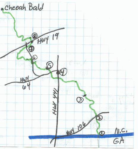
1.NC/GA border. Hale Ridge Road
2.HWY 106- Osage Mtn. Overlook
3.Buckeye Creek Trail Head
4. City of Franklin
5.Wallace Branch Trailhead
6.Phillips 66 Gas Station on SR 1310
7.Bike Path
8.Winding Stairs Parking Area, off HWY 19