My ebooks The Passion Killers, A Dark Wind of Vengeance, Blood Beyond the Abyss and The Second Layer of Hell (apocalyptic fiction) are now available for download. They are the first four installments in the Path of Survival series. To see additional information, click here .
The Foothills Trail is approximately 76 miles in length and it is located in the mountains of South Carolina and North Carolina. The route is located south of Rosman, NC, east of Walhalla, SC and west of Greenville, SC.
The southern terminus is located in Oconee State Park in South Carolina (accessible from Hwy. 107) and the northern terminus is located in Table Rock State Park, which is also in South Carolina (accessible from Hwy. 11). Elevations range from about 1,000 ft. at Table Rock State Park to about 3,600 ft. at Sassafras Mtn.
A guidebook and additional information is available from The Foothills Trail Conference, PO Box 3041, Greenville, SC 29602. Their website is located at www.foothillstrail.org .
My Foothills Trail videos at YouTube:
Part 1 (on left) - Oconee State Park to Bad Creek Access Trail
Part 2 (on right) - Bad Creek Access Trail to Table Rock State Park
**
My journal is shown below:
Oconee State Park (34N 51.825, 83W 05.889) to Cheohee Rd. parking area near Hwy. 107 (34N 54.878, 83W 06.640) Distance: 6 miles
Wild Iris (Blue Flag)
April 9, 2008 - Carol and I hiked this section on a beautiful early spring day. She hiked the Foothills Trail in 2005, and agreed to hike it again with me. The day was warm and sunny, and it was great for us to be hiking together in the mountains again.
After leaving one vehicle at the Cheohee Road parking area, we drove to Oconee State Park. The park was easy to find, but it was difficult locating the Foothills Trail terminus. After we had been driving and walking around aimlessly for about 10 minutes, Carol asked a ranger for help. Here are simplified directions: After entering the park, go right at the first intersection. At the next intersection (after going past a large wooden building advertising canoe rentals), go left. After the Stop sign, go about .75 mile, and the trailhead will be on the left. The parking area is about 100 ft. past the trailhead on the opposite side of the road.
The trail in this section is located on newly constructed sidehill trail, with excellent signage. It appeared to be well maintained. The treadway was in good condition, but there were a few blowdowns. There was also evidence that several large blowdowns (that would have made the trail nearly impassable) had recently been cleared.
After hiking about an hour, we reached Long Mountain. The trail goes just below the summit. It is hard to miss Long Mountain, there are about a half dozen communication towers at the top of it. There were some fair-to-good views, but I expect that the views will disappear later in the spring when the hardwoods are no longer bare and leaves are present.
We made a moderate descent and were soon crossing several creeks on small bridges. There are numerous good camping sites (with water) in the vicinity, located near the halfway point of this section. We saw numerous early-season wildflowers, including yellow and purple violets, wild iris and aster. A few dogwoods were also blooming.
We soon encountered Hwy. 107. The trail doesn't cross the highway here, but does parallel it for a short distance on an old roadway before heading away from the highway on sidehill trail. After encountering one of the most "anatomically correct" double-trunk trees that we have ever seen (hint: we dubbed it the "Mother Earth" tree), we began a descent that took us the parking area at Cheohee Road. Hiking time for this section was about 3 hours.
Cheohee Rd. parking area near Hwy. 107 (34N 54.878, 83W 06.640) to Burrell's Ford Rd. parking area (34N 58.284, 83W 06.905) Distance: 10.4 miles
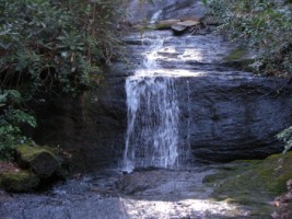
King's Creek Falls
April 16, 2008 - Carol and I hiked this section on a cool but absolutely beautiful spring day. It was 28 degrees when we left home about 8:00 a.m., which was a record low temperature for this date. After leaving one car at Burrell's Ford Rd., we drove to Hwy. 107 and began hiking north.
For the first few miles we descended into the Chattooga River Gorge, hiking near Licklog Creek and Licklog Falls. We passed the intersection of the Bartram and Foothills Trail and continued to descend until we finally reached the bottom of the gorge and the Chattooga River. Despite the "drought" that the TV weather people are always talking about, the water was roaring and the river was really putting on a show. The water flowed over falls and cascades into beautiful emerald pools. I found myself wondering why it has taken me 20 years to hike this great section of trail that is less than an hour's drive from home.
After a couple of miles of hiking very near the water, the trail left the river and we began to "ascend steeply". This section is not well blazed at all. At times we weren't sure we were on the right trail, but we knew we were still in the gorge (and the river was at the bottom of it), so there wasn't much chance of getting really lost. Soon we were descending again, and when we reached the river, the trail deteriorated badly. It appeared that no maintenance had been done for a while and we really got slowed down by the poor treadway and numerous blowdowns. In addition, lots of thick rhododendron branches were encroaching. We were constantly having to duck under them.
Trail maintenance improved as we got closer to Kings Creek Falls. Carol took a break at the intersection with the Kings Creek Trail, and I went to get a video clip of the falls. I'd seen the falls a couple of times previously (years ago), but they were a lot higher than I remembered. I'd estimate their height to be 80 - 90 feet, and they are nearly sheer. In my opinion, this is one of the most spectacular waterfalls in the area.
After I took a break and had the last of my water and snacks, we hiked the remaining .5 mile to the parking area. This had been a beautiful but physically demanding hike, and we were both ready to reach the car. We'd seen no other hikers the entire day. In fact, the only signs of civilization we'd seen were the remains of an old fishing rod down by the river, and an old sock. Hiking time for this section was about 7 hours.
Burrell's Ford Rd. parking area (34N 58.284, 83W 06.905) to Sloan Bridge parking area (35N 00.207, 83W 03.217) Distance: 7.2 miles
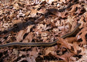
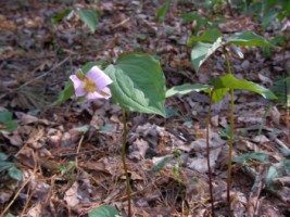
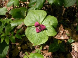
Eastern Ribbon snake, blooming Trillium & Way Bigger Falls
April 21, 2008 - We parked a car at Burrell's Ford Rd., then drove to Sloan Bridge parking area on Hwy. 107 and began hiking south. This is a fairly easy section of trail that contains many creeks and several waterfalls. However, there aren't many camping areas near the creeks.
Soon after beginning our hike, we encountered an Eastern Ribbon snake on the trail. These guys have no venom, but they do have teeth and will use them if someone gets careless while handling them (I have a scar on my right hand as a reminder). It was just over 2 ft. long, remained motionless and didn't seem to mind posing for a photo.
Blooming trillium is one of my favorite wildflowers, and it was abundant throughout the entire section. We also saw wild iris, violets, mayapple, blooming dogwoods, aster and a few other species that I couldn't identify.
When Carol hiked this section of trail in 2005, she wrote in her journal that she had encountered a waterfall about .75 mile south of Hwy. 107. The guidebook erronously listed the height of the falls as 6 feet. She wrote that she is 5 feet tall, and since the falls are Way Bigger than her, she figured the guidebook was wrong. Since the guidebook didn't mention the name of the falls, I decided to call them Way Bigger Falls. The falls are actually about 60 feet high, but only a few feet wide. We stood for a few minutes on the little bridge that is just below them, and I took a couple of photos and a video clip.
We were descending toward the southwest on the east side of the Chattooga Gorge, hiking just below Hwy. 107. It was very pleasant hiking on sidehill trail and long, gentle switchbacks. Soon after encountering some nice views of Whiteside Mountain in North Carolina and several more small waterfalls, we crossed the road that accesses the nearby fish hatchery. A while later, we took a long, leisurely lunch break, knowing we were only about 2 miles from our destination.
We continued descending into the gorge and about a half-mile after passing the intersection with the Chattooga River Trail, we were back at Burrell's Ford Road. Hiking time for this section was about 4.5 hours.
Bad Creek parking area (35N 00.736, 82W 59.954) to Sloan Bridge parking area (35N 00.207, 83W 03.217) Distance: 8.5 miles
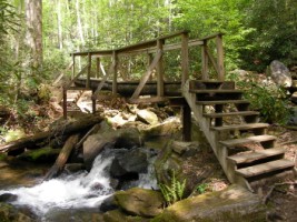
Footbridge over creek, Whitewater River Bridge & Large Flower Trillium
May 1, 2008 - After leaving a car at Sloan Bridge parking area on Hwy. 107, we began our quest to locate the parking area at Duke Power's Bad Creek facility. After making several wrong turns, we finally found the parking lot, and I had to laugh. To begin with, the Foothills Trail is not used by large numbers of hikers. In addition, the Bad Creek area is very remote, and it is hard to find and it is gated. However, the parking area is the size of a football field, or maybe a Wal-Mart parking lot, easily able to accommodate 100 vehicles.
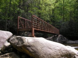
Leaving Carol's little blue Geo looking all lonely and forlorn in the enormous, lighted and paved parking lot (it was the only car there), we began our hike on the .7 mile access trail that intersects the Foothills Trail at the Whitewater River. The trail was well marked, and about 20 minutes later, we crossed the river on two metal bridges and turned south (left) on the Foothills Trail, hiking back toward Sloan Bridge and Oconee State Park. Walking along the river was very nice. The weather was warm and sunny, and spring plants were blooming all over the place. After about a mile, the trail turned away from the river and began paralelling a small creek. A while later, we crossed the creek on a wooden bridge and found ourselves at the base of a very large waterfall.
The scenery was absolutely beautiful in this section, and we really got slowed down taking photos and video clips. We crossed the Whitewater River again on a nice metal bridge, but it was necessary to do potentially dangerous rock-scrambles on huge boulders to get on the bridge, and to get off of it. Because of this, I dubbed it the Evil Knievel Bridge. After we crossed the river, we began our long, difficult ascent out of the Whitewater River Gorge. The trail was steep and rocky, and there were many steps and wooden staircases.
Several hours later (after we were out of the gorge), we reached some wooden benches and took our lunch break, knowing we were about 3.5 miles from our destination. We had excellent views of Lake Jocassee (where I scuba dive) and the surrounding mountains. We expected to trail to be "all downhill" after that, but it never seems to work out. Despite the fact that we had to make a sizable descent to reach Hwy. 107, we kept going up and down, gaining and losing the same 200 - 300 feet in elevation. However, the treadway eventually evened-out, and we began hearing highway sounds. The trail paralelled the highway for a while, but soon we were back at our car at Sloan Bridge. Hiking time for this section was about 6 hours.
Bad Creek parking area to Bearcamp Creek Distance: 6.6 miles
Yellow Violet
April 11, 2009 - The mileage of 6.6 miles for this section includes the .7 mile access trail from the parking lot at at Bad Creek to the Whitewater River. Hiking time was about 5 hours. Unfortunately, there will be no GPS coordinates included in my trail journal for this portion of the trail (from Bad Creek Parking Area to Table Rock State Park), since I neglected to bring my GPS unit.
Before we started to hike this section, we shuttled a vehicle to Table Rock State Park. Then we had to do battle with the bureaucrats for over an hour in order to get a trail permit, a parking permit and find the parking lot where we were expected to leave Carol's car. To make this as painless and simple as possible, I'd suggest going directly to the Visitor Center at park headquarters (there's a sign on Hwy. 11) and get the parking permit. After getting that permit, get directions to the area where you are supposed to park. Very close to this Day Use Parking Area, you'll find the Interpretive Center, where you can self-register for the hiking permit. However, be forewarned, we were told at the Visitor Center that if we were not back to our car on the date indicated on the parking permit, that a Search & Rescue operation would be instituted on our behalf the next day. And it is standard procedure for these folks to bill hikers for the cost of Search & Rescue operations.
After driving my car back to Bad Creek parking area, we began our hike on a beautiful but somewhat windy day. It was great to be back on the Foothills Trail after an absence of almost a year, and the Whitewater River was as beautiful as I'd remembered it. After crossing the two bridges, we turned right and began our hike back to Table Rock.
It was an early spring day, and several species of wildflowers were in bloom, including wild iris, violets, bloodwort and bluets. The hardwoods were just beginning to get leafy, and the dogwoods were also beginning to bloom.
The trail was fairly easy until we began our descent to the Thompson River. Then we began to encounter lots of steps. We took a break at the river and some folks who were camped there invited us to camp with them. However, it was early and we decided to keep hiking. We arrived at Bearcamp Creek about 6:00 and made camp. There were some other folks camped about .1 mile to our north, but we found a beautiful little site near the creek, alongside what we thought was an abandoned logging road. We found out later we were wrong.
About 1:00 a.m., I was awakened from a very sound sleep by the sound of a straining car engine. Then headlights hit my tent. I looked outside to see an older model Ford 4-wheel drive pick-up truck sitting directly between my and Carol's tents. We used separate tents on this trip because Carol was testing a new solo Eureka Spitfire1 tent that she just received. I normally carry a 12-gauge flare pistol and several flares with me in bear country. If a ranger ever sees it and asks me about it, I'll say that it is just for signaling in case of an emergency. However, its real purposes are self-defense and providing attitude adjustments for marauding bears. When I saw the vehicle, I loaded the flare gun and waited to see what happened next.
There was a nearly full moon, and one of the guys in the truck must have seen that I was holding some kind of pistol, because he said, "Don't shoot; we don't have any guns. We don't want any trouble, we're just looking for a dog". I didn't say anything, just continued to sit in my tent while looking at them and holding the flare pistol. He then asked me if I'd seen a dog anywhere, and I said I hadn't. He then offered me a beer (which I declined), said they were sorry for disturbing us and eventually left. Carol came over, and I explained what had happened. It was several hours before I could get back to sleep.
Bearcamp Creek to Rock Creek Distance: 12.4 miles
Trail under boulder, Steps at Horsepasture River & Toxaway River Bridge
April 12, 2009 - After the scary incident with the people in the Ford 4WD in the middle of the night, I was glad to see the sun come up. Carol and I were out of our tents at first light, and talked about what had happened the previous night. She had made the correct decision to stay in her tent during the ordeal, thereby not letting the folks in the truck know that there was a woman in the other tent. For all they knew, our group consisted of several men. I'm not convinced that they had been looking for a dog. They may have been there to harass and rob us (or worse), then changed their minds. I suppose we'll never know for sure.
At any rate, it was good to pack up and get back on the trail. We began encountering a massive amount of steps. On the northern half of the trail, it appears that to the greatest extent possible, the trail engineers put the trail on old logging roads. Then they built several short, steep sections of trail using steps to connect the logging road sections. In addition, there are lots more steps used to descend to (and ascend from) the rivers.
The Horsepasture River is beautiful, and we took a break before we crossed the suspension bridge. Carol counted 105 steps on the first section of steps on the north side of the river. Ascending and descending steps was pretty much the order of the day.
Later, we descended to Lake Jocassee and crossed the Toxaway River on a beautiful 225 ft. suspension bridge. The campsite was high and dry since the lake was down about 18 feet, so we decided to keep hiking.
After making a knee-jarring ascent from Lake Jocassee only to make another knee-jarring descent to Rock Creek, we decided to camp. Hiking time for this section was about 9 hours. We had a beautiful campsite with the little creek and some blooming dogwoods nearby, and there was not a cloud in the sky. However, I was awakened about 1:00 a.m. by the sound of rain hitting my tent.
Rock Creek to stream .8 mile south of Chimneytop Gap Distance: 12.1 miles
Trail in fog, May Apples
April 13, 2009 - After cooking breakfast and packing up in the rain, we began our ascent from the Toxaway River gorge. Later, we began hiking along Laurel Fork Creek. We crossed the river at least 15 times on very well designed wood bridges. It was very easy and scenic hiking.
We took our lunch break at Laurel Falls and then continued hiking in the rain. Several steps that had been washed away by the recent rains created a dangerous situation for us. We had to scramble up slippery, muddy and rocky slopes while grabbing any type of limbs or vegetation we could find. To the trail engineers, building a massive amount of steps must have seemed like an inexpensive alternative to building switchbacks, but steps are "high maintenance". And if they are not maintained on a regular basis, they loosen and become useless at best, and dangerous at worst.
By the time we reached Laurel Valley at US Hwy. 178, we were tired to the point of exhaustion. The guidebook said we would be descending from here, but it was wrong. We found ourselves making a steep ascent that seemed to go on forever. By the time the trail leveled out a bit, we were desperately looking for a place to camp. We also needed water. About .8 mile south of Chimneytop Gap, we located a nice campsite on the east side of the trail. The small creek beside it was flowing with a small but adequate amount of water. We kind of collapsed into camp and put our tents up in the rain. After making a quick supper, we were in our tents before dark. The rain continued all night. Hiking time for this section was about 9.5 hours.
Campsite .8 mile south of Chimneytop Gap to Table Rock State Park Distance: 14.1 miles
Cave at Drawbar Cliffs, View towards Table Rock State Park & Rocky ledge with waterfall
April 14, 2009 - According to the weather forecast, the rain was supposed to stop by the morning, but it didn't. We packed up again in the rain and cold and began our ascent of South Carolina's highest peak, Sassafras Mountain (3,554 ft.). The entire mountain was foggy and drizzly, and there were no views from the summit.
We later hiked past an old homesite. Only the chimney remains. I couldn't understand why someone would build a house where there was no water available. The guide book didn't mention any springs or creeks, and we briefly inspected the site ourselves, and didn't see any water sources. Had people actually lived there full-time, or had it been a summer home? Had there been road access? Where did they get their water?
The weather finally began to clear. We hiked past beautiful Drawbar Cliffs; spectacular rock faces that are several hundred feet high. I expect the area is popular with rock climbers, though none were around when we hiked past.
After we entered Table Rock State Park and began descending, we had problems following the trail. And when we did find the trail, it went straight across some slick boulders. I'm a a bit surpised that neither of us suffered any falls.
The trail has recently been rerouted, and apparently it is longer now by several miles. It seemed to take forever to get down to the Interpretive Center where Carol's car was parked, but the trail afforded us many views of spectacular waterfalls. If we hadn't been so tired and eager to finish our hike, it would have been more enjoyable.
Finally, we reached the car about 5:30, and hiking time for this section had been about 9.5 hours. Despite our best efforts, we couldn't get back to Bad Creek parking area to retrieve my car until 6:26. There was a sign on the gate stating that the gate was locked each day at 6:00. We had no choice except to leave my car where it was, make the 50-mile drive home, and go back and get it the next day. The Foothills Trail is absolutely beautiful, and it packs a lot of scenery into its relatively short length, however, I've had enough of bureaucrats, parking fees and hiking permits to last a while. And as Carol said, this was the first time we'd ever been threatened with a Search & Rescue.
.jpg)

.jpg)
.jpg)
.jpg)
.jpg)
.jpg)
.jpg)
.jpg)
.jpg)
.jpg)
.jpg)
.jpg)