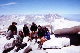
Ben, Alexa, Citrus, Amy and Brent. I am in the grey silnylon jacket on the rock
June 10 - Cooked breakfast, and Ben and I were on the trail at 7 a.m. It’s quite overcast, with a line of blue to the west. We’re going to summit, if at all possible. Mt. Whitney is the southern terminus of the John Muir Trail. Without a summit of Whitney, there’s no point in finishing the JMT in Yosemite Valley. Everyone has stripped down their packs, placing gear and extra food in the bear box. My external frame is reduced to one stuff sack with clothes, snacks, one full water bottle, ice ax and rain gear. It weighs about 5 pounds total and feels like nothing.
There was ice on the log when we forded the creek. An hour later, we came to Guitar Lake. Marmots watched us as we forded a another rushing creek. The clouds moving eastward gave us hope the weather would clear. Snowfields began to appear. It was just Ben and I; the others followed later. Ice was still on the trail and key rocks used for climbing were covered with thick ice. “Just follow the footsteps, don’t worry about the trail”, Ben called to me as I approached a set of 3 switchbacks. He waited at the top of that section, then cautioned not to touch the icy rocks. On hands and knees, I pulled myself up and over. We gained 4,500 ft. of elevation in 7.5 miles. It was mentally exhausting having to watch for ice, snow and loose tread with every footstep. Plenty of water on the trail, there was no need to carry any extra. At 13,000 feet, Ben and I sat down for a snack. Then we began to see other hikers above us.
Since it was Sunday, many day hikers appeared on the Whitney Portal Trail, which joined ours just 1.8 miles from the summit. Some carried crampons, ice axes and packs. They seemed winded, their's being a longer and steeper trail. Near the summit, there were some harrowing ice mounds covering the trail, requiring axing-in and pulling myself over and onto a narrow ledge. We picked our way to the top, much of the trail obscured with snow or boulders. There were sunspots from the day before, and we were careful to avoid those lest we posthole.
We summited at 12:15 and stayed until 2:00 p.m, snacking and chatting with the many people up there. We signed the registry by the stone hut. The highest outhouse in the contiguous U.S is up there, and several of us experienced the great wildness as wallpaper. How interesting to think of a helicopter coming to empty this facility.
Going down was easier as the snow became soft and mushy. Nearing Guitar Lake there was so much snowmelt that I lost the trail and bushwhacked straight down, seeing the JMT below. Ben had gone ahead and I took a little extra time.
I had no problems with altitude sickness. I’m loving my high top trail runner shoes. Fewer stones get in them than the low tops. They are heavier however. Tried some smart wool socks today on the hike and like them, too. My feet stayed warm and comfortable, even though sopping wet by day’s end.
Arrived back at Crabtree Meadows tired but elated.
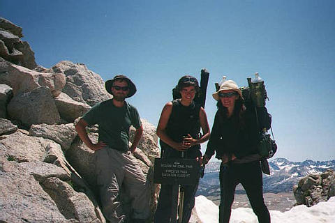
June 11 - Left early this morning, as is the custom of my friend, Ben, whom I’m hiking with. Alexa met us on trail. Together we forded 3 streams barefoot, then pressed on to Forester Pass, highest point on the PCT at 13,200 ft. Snow reportedly awaited us and we needed to get there before it refroze in the evening. The climb was steep, the preceding area full of snow with water underneath it. We could see the trail snaking up the south side, but snow covered the approach to it. We finally climbed the southside, wondering, and affirming, that yes, the trail was taking us through that tiny little notch. A narrow snow chute had to be crossed just before we summitted. On top, three southbound John Muir hikers lay with their shirts off, hot from the difficult south climb. They pointed the way down.
Finally found the northbound trail. Below us was all snow on the north side, footprints traversing the slope. Because it was late afternoon (2:30), it felt like X-country skiing; little postholing. Alexa, Ben and I all like that sport, so it felt okay. Once we reached real tread, we made chocolate slushies with snow, hot cocoa powder mix, in our empty peanut butter jars. Delicious! Pressed on to Vindette Meadows, where there is a bear box. Hiked 21 miles.
Things You'd Rather Not Hear:
-"It's all down hill from here." - Somehow those word always precede the worst of sections, but draw one into an insanely huge mile day.
-"The prices there are pretty reasonable for California." - Means outrageous to normal folks.
"Those aren't wild onions."- after you just put a handfull of some greenery into your last ramen noodles.
-"So are you having fun?" - Hunh, you mean I'm supposed to be?
-"There's a horse camp upstream." - This just after you'be drank a quart of untreated water from this lovely creek. Oopsey!
June 13 - The clouds blew over and we awoke to a clear day. Today, Pinchot Pass and Mather Pass are the objectives. Reportedly, neither is bad, so we felt that doing both passes on the same day was doable. We even managed to pull it off. Hiked 22 miles and camped in a sweet place, tired but happy for the beautiful trail and friends I share it with. There is abundant clear water. some are electing not to treat it until we get closer to high traffic areas.
June 14 - A big day planned, seemingly impossible, but two objectives loom. One is Muir Pass, reportedly a heavy climb. The other is Evolution Creek; cold and deep and 12 miles beyond the pass. Hoping to ford it in the evening, rather than in the cold of the next morning, we pressed up Muir Pass. I found myself frustrated by lack of calories and slogging through miles of snow. The last miles were more a searching for footprints, avoiding sun spots and underwashed snowfields. The PCT / JMT doesn’t always summit the low spot at the pass, so we were at times guessing and checking maps to find our way. Thankfully, I was with Ben. Two sets of eyes are good at times like this. Footprints of varying age headed in 3 directions.
We reached the hut at 1:00 p.m. I cooked a pot of hot oatmeal and coffee, my lunch in the cute, stone Muir Hut. We headed down about 1:45, bushwhacking and slogging through snow and fording snowmelt streams, finding a 100 yard section of trail every mile or so. Dry feet and shoes became moot points as we just waded through stream covered “trail”. Surprisingly, once it got down to Saffire Lake and Evolution Valley, it opened up to us, and we were able to make Evolution Creek. We crossed it about 7:40 p.m., only thigh-deep on me. I cross barefoot, almost driven crazy by bloodsucking opportunists! Mosquitoes! 24 miles today!
June 15 - With Vermillion Valley Resort only 27 miles away, I enjoyed the last bites of my food, saving a breakfast for tomorrow. Having been on trail for 9 ˝ days, anything is going to be good. We've been eating young wild onions, and adding washed wild onions to our suppers at night, stretching the food supplies. Now, at this point, money seems unimportant. Clean clothes and hair without every last strand coated in dust worth everything! The ferry ride will be a luxury, I will call / e-mail home. Oh, the plans and fantasizing! We hiked 22 miles, though weary, muscles giving warnings, muscles that never complained before. Met some new people. One young man seemed filled with fear, talking about all the bad things that could happen to people. He even skipped a section due to fear of bad water. Fear is a very negative force; deadly to dreams. I have been very afraid many times. Hate to let it beat me without a fight, though. Camped at the top of Bear Ridge; without water. The data sheet says there is some at the top here, but none was apparent. Thats ok...only 5 miles and it’s all downhill to Vermillion Valley Resort.
June 16 - Got up early and was on the trail by 5:30. Fifty-four switchbacks awaited me, according to the guidebook. There is a ferry at 9:45 and I must be on it!
Hiking solo, and half way there, I was fortunate to see the large bear grazing. He ran off after I whistled. The ferry holds only 5 – 6 people and sometimes they dock at different places depending on the water level of the lake. Fourteen hikers waited with me, and when the ferry docked up lake, I ran to catch it, laughing as the boat man called, "I can only take 5 at a time." I was lucky to be on the first shuttle.
Vermillion Valley Resort runs a tab for hikers, your name on a card. Everyone at the resort is so friendly. It is clean and the first night in a tent “cabin” is free. I have a lower bunk. I share this tent with 3 other young 20ish women. The first beverage is free, also. Someone brought a pile of food, put it on a bunk in one of the tents and said to help ourselves. We ate that, also. Showers are $5, but I wanted to see how tan I really was. Found some peppermint shampoo in the hiker box; so lovely! Ben and I shared a load of laundry for $2.50 each. Things are looking good.
There’s a big BBQ tonight. It costs $12.95; smells good, fresh homemade pies, too. I guess this being on trail for 190 miles makes me love any little luxury. Lots of hikers here (13) and some others leaving out. Very good vibes.
Met Coppertop, who knew me from online, and as requested, I put up the Cherokee tent for him to inspect.
June 17 - Spent the day relaxing at Vermillion Valley. Had a “short stack” of blueberry pancakes with blueberry topping and syrup for breakfast. They completely filled the plate and I couldn’t finish them. With the bottomless cup of coffee, and all for about $6, I was a happy customer.
Lots of hikers leaving today so the boat man will probably make at least 3 trips. I have been pleasantly surprised by how nice my stay here has been. The scenery is beautiful and everyone is very friendly. Doing some math to slow down my mileage, figuring out what I will do with a week off as I wait for Rainmaker to meet me in Reno on July 13 to finish hiking north of Crater Lake to Manning Park, Canada.
Later, hiked 4 miles to camp by a stream. Only 26 miles to Red’s Meadow. I am hauling lots of food, treats and candy. This seems to be a common overreaction among the hikers who do the long stretch from Kennedy Meadows to Vermillion without resupply. It is rare. Most seem to get a resupply at either Lone Pine, Independence, Bishop, or mail a box to the John Muir Ranch.
June 18 - Hiked to within 3 miles of Red’s Meadow, which made it a 23 mile day. I am eating well because I have only 1 ˝ more days of hiking before I arrive at another store. I hauled lots of goodies out of Vermillion and I’m eating like crazy; cookies, gorp, gourmet coffee, red licorice. This is my reward for last week’s hunger.
Reportedly there are 2 pay phones at Red’s Meadow. After $2 per minute from a cell phone (not even working properly) at Vermillion, those pay phones will be very busy. Marty let me use his pocket mail, so I wrote an e-mail to Rainmaker, and all messages were downloaded for one minute cost. I plan a long call home, and will not leave there until I get it!
It’s no wonder people plan to hike the John Muir Trail, even if they never get to do another trail in their whole lives. It’s an incredible place; plenty of water and lush meadows, high passes, innumerable waterfalls and cascades, wildlife and flowers. There are also beautiful clear skies and ice covered turquoise alpine lakes with snow covered ridges around them. We plan to finish the JMT by day hiking to Yosemite Valley from Tuolumne Meadows. We will then get a ride back to Tuolumne Meadows and continue north on the PCT. I consider myself fortunate to be able to do this.
June 19 - Hiked 3 miles into Red’s Meadow and 4 miles out. I resupplied to Tuolumne Meadows, buying a 24 oz. loaf of wheat bread, 18 oz. plastic jar of peanut butter, 13 oz. bag of Doritos (Nacho Cheese flavor), 8 oz. cheese salsa (finished and threw away the jar before heading out), 4 king size candy bars and 11 black licorish sticks. While enjoying the free hot showers near the campground, I placed the cheese salsa on the ledge of this enormous cement tank inside the little room that was mine. Opening the chips, I basically ate while showering and washing trail clothes. Now, if that ain’t living, I don’t know what is! All the free hot water you could want, in a private room, eating junk food and not worrying about the calories!
It is early in the season, and the store had just opened that week. No wonder the shelves were sparce.
True to form, the pay phones were in constant use, I spent over 2 ˝ hours on them myself. Lots of catching up to do and information to verify since Kennedy Meadows. We also had breakfast at Red’s Meadow and all 8 of us hikers agreed the meals were expensive and the portions were small. Then again, these friends of mine are mostly from the east coast and have enormous appetites and limited budgets.
We are, generally speaking, not into possession of things, but value possession of experience. The few things we have with us are well worn with daily use and their respective weight in ounces quoted on request, or even in defiance, as in “Yeah, well, this 4 pound camera is taking pictures that will last me a lifetime!”
I have seen several PocketMails, cell phones, guitars, and tiny radios. Each person perhaps has one “luxury” item. But this one JMT hiker put it so precisely, “Seems like the longer your hike is, the less you carry”.
June 20 - Hiked 20 miles, up and over Donohue Pass, and camped. I crossed a wide, snow-melt stream barefoot this evening, not liking the looks of the boulder hop and strong current flowing over the rocks. The water was ice cold and knee deep in places, however, this method works for me because my feet are used to barefootedness. I was numbed to the bone, glacier melt will do that every time.
Today was spent circumnavigating beautiful lakes along the 12.9 mile JMT section that doesn’t coincide with the PCT. There are so many lakes, crystal clear, but camping isn’t allowed near several of them. So much traffic puts enormous strain on the delicate environment here. We ate lunch by Ruby Lake, passed Thousand Island Lake and then we were back on the PCT / JMT Trail. There are many people for so early in the season. Several young men fishing by their "own lake" and decided to move to another one, met and talked with us briefly.
Trout abound in all these lakes and streams. Ben, (AT trail name “Cobweb”) is wistful. Already he plans a fishing trip when he returns to his home in Vermont. Non-resident fishing licenses are $90 in California so I’m told; beyond time and financial considerations.
Have not seen any of our friends today, but mainly JMT and week hikers. Can’t imagine what it must be like here in a month or so.
Writing out my goals for the last leg of my solo journey, I have hiked this last month with a lot of the same friends, especially Ben & Alexa. But, we all know our solo standing. I have 153 miles from Tuolumne to Echo Lake, and hope to carry out 11 days of food, take it slow and rest a little before my partner Rainmaker meets me for our last section. The thru-hikers must keep up their 20+ mile days in order to complete their journey in one season. I must slow down to meet my time frame. It's been great, and challenging, but the time has come to shift gears. However, I will miss seeing them on the trail. Those behind me will catch up and pass. Trail friendships are just that and seldom continue into the other world. We love what we have when we have it, we let go what we must when it’s time.
My words or photos can never convey the quality of the unfolding Omnimax panaramas, complete with birds singing, marmots whistling, water and wind rushing, soaring eagles, circling ravens, dark clouds threatening and lightning flashing. The tall, magnificent, sculpted trees, tender shoots and flowers so delicately clinging to a cliff 12,000 ft. up. This was no postcard trip; it was the total surround of an Omnimax theater.
******Fording A Creek*******
I've learned alot about fording a creek since I started in Campo. First let me describe and define a PCT "creek". Out here anything with water flowing is either a spring, streamlet, lake outlet, or a creek. Back home some of these would be classified as Class 4 Rivers.
There's Evolution Creek, Bear Creek (there's gotta be at least 5 Bear Creeks out here), Kerrick Canyon Creek, Stubblefield Canyon Creek, Kennedy Canyon Creek, ect. The trail will parallel, from a ridge, one of these puppies as it roars down canyon. In the back of your mind runs the thought, "How on earth am I gonna ford that thing?"
But, thankfully, it crosses at a fairly benign place where its widened and slowed and most boulders are at least not in motion now.
Usually the trail resumes directly across the creek and the objective clear. A simple rock hop is possible in many steamlet crossings, the rocks having been placed a long-legged man's stride apart. Once, when I had already committed myself to such a hop, seeing the next one an impossible 4 feet away, I devleoped what I call the "Sacrifice the Queen" manuever. In chess, the dumbest move apparently is to lose one's queen, the most powerful piece. However, it may save the whole game . Thats what I call putting ones foot on a slightly submerged rock, and using it to complete the ford. It appears unskillful, but to any sneer of laughter, I simply state "I sacrificed the queen." That ususally shuts them up with a look of complete confusion.
Sometimes a creek crossing looks like a baredoot necessity. Nothing immediate presents itself. Then ensues running up and downstram to find an easier place; a partial log, met by a boulder, a point peeking out. That's all one needs.
Ice may be present. The logs may be unstable. Hiking poles definitely help here. Its an art form.
When all else fails, off come shoes and perhaps socks. Laces tied in a knot and shoes slung around the neck, a crossing is slowly made diagonally down stream, allowing the current to bring you and the thousand feasting mosquitoes ashore. No grimace or groaning is allowed for a Classy Crossing. This barefoot crossing has the benefit of some thorough cleansing action for feet as well as socks.
One evening, after much stream crossing, I simply walked across in my shoes. Took those puppies 2 days to dry out. Don't think I will do that again. Its cold in the morning!
June 21 - Hiked 11 miles in to Tuolumne Meadows this morning, where there is a post office, café and store. Had a great time hanging out with hiker friends. At the same time we realized that these tourist crowds are not easy to maneuver around. I don’t believe I’ll spend any time in Yosemite Valley, but plan to hike down tomorrow, completing the JMT, and get back here to the backpackers campground by evening.
The grill (café) here has good food and service. The store is good, with camping supplies, food, postcards and everything in personal care products. Prices are reasonable, especially for California.
There is a small gear shop just a bit down the road. There we were able to buy 100% deet. Anything less just brings dirision and no mercy from these insects of torture.
The lady at the post office allowed me to stash a few items to lighten my pack for the hike to the valley. In this very crowded campground, I would not leave anything in the bear boxes.
June 22 - We got up early, made our way through the campground and found the John Muir Trail. Everyone said it was all downhill, but the first 5 miles weren’t. We had been told it was only 24 miles to the northern terminus, but later discovered it was more. Spent the day hiking the 27 miles to Yosemite Valley. Hiked past beautiful Unicorn Peak and later had beautiful views of Yosemite Valley from the vicinity of Nevada Falls. None of my companions elected to climb Half Dome, although we could see those on the wall who had come up for just that purpose. Goslowgofar hiked in to meet us from Yosemite Valley and we met her just past the cut off trail to Half Dome. Finished the JMT at Yosemite Valley, then Goslowgofar took us to a pizza place, a store to resupply at, and then brought us back to Tuolumne Meadows. It was greatly appreciated, and we had a wonderful time. There is a bus that runs from the valley back to Tuolumne, if one could not find a ride.
We set up our tents in the dark, in the backpackers campground, by photon light. Around 2 a.m. stealth campers arrived, and it was noisy for a bit until they settled down.
June 23 - Slept in, and spent that day hanging out, meeting in coming hikers, resupplying and doing mail. Many people are here, day hikers, vacationers, thru hikers, and well wishers. It was a great trail, and I am very glad I hiked the extra 42 miles to complete the JMT, in addition to doing the PCT.